In the mid-1920s, Nevada Governor James G. Scrugham decided the time was right to create a system of state parks. He issued a proclamation listing 15 potential “State Recreational Grounds and Game Refuges” and signed a bill allowing the state to trade state owned land for federally owned sites that could be used for recreation.
A 1927 appropriation bill to pay for the transfers specifically noted a handful of potential state park areas including, “the Hidden Forest and the Valley of Fire in Clark County, Cathedral Gorge and Beaver Dam in Lincoln County, the Petrified Forest in Humboldt County, the Opal Fields in Esmeralda County, and Old Fort Churchill in Lyon County.”
While four of those sites eventually became state parks—Valley of Fire, Cathedral Gorge, Beaver Dam and Fort Churchill—three never became state parks and have nearly disappeared from most recreational maps.
So what were the Hidden Forest, the Petrified Forest and the Opal Fields? And why were they once considered important enough be mentioned on the initial list of future park areas?
Historical records are sketchy. When Nevada formally created the state park system in 1935, four sites were designated including Valley of Fire, Cathedral Gorge, Beaver Dam and Kershaw Canyon (known as Kershaw-Ryan State Park). Fort Churchill was being stabilized for future consideration as a state park.
But no mention is made of the other three sites.
However, a review of old state park records and other sources reveals a bit more. A 1938 report, “Park, Parkway and Recreational Area Study,” prepared by the Nevada State Park Commission, includes a map of “potential” state park areas.
Among the places listed are: “Petrified Forest,” now located in Esmeralda County near the Fish Lake Valley, “Opal Fields,” now in Humboldt County near the Black Rock Desert, and “Hidden Forest” in Clark County near the Sheep Range.
In all likelihood, the county locations of the Petrified Forest and the Opal Fields had been reversed in the earlier legislative description.
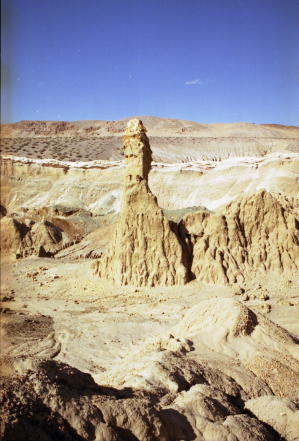
With this knowledge and maps of their locations, the significance given to the three sites become easier to understand. The Petrified Forest site was most likely the area now known as “the Sump,” a large drainage gulch, once the bottom of a prehistoric lake that contains the remains of ancient petrified tree stumps and twigs. It is located a few miles from the intersection of State Routes 773 and 264.
This remote site remains an impressive geologically significant place with its otherworldly appearance enhanced by massive multi-colored cliffs. Over the years, a number of folks have suggested it be designated a park or protected area because of its relatively untouched natural beauty but to date no action has been taken.
Interestingly, there is a Petrified Forest site in Northern Washoe County near its border with Humboldt County. Called the George W. Lund Memorial Petrified Forest, it is a Bureau of Land Management preserve that contains the fossilized remains of about 250 tree stumps buried by volcanic ash 15 million years ago.
Unfortunately, the site was unprotected for many decades and, according to a 2005 report of the Botanical Society of America; bulldozers and dynamite have removed some of the stumps.
Additionally, the BLM is studying means to minimize the effects of freezing and thawing of the remaining stumps. A large portion of the site, which is adjacent to Nevada Stare Route 34, about 35 miles north of Gerlach, was fenced in 1965 by the BLM and a small monument was erected.
It is believed that the second forgotten park site, the Opal Fields in Humboldt County, most likely referred to the Virgin Valley, located west of Denio in far Northern Nevada. This region is famous for its black fire opals—the world’s largest example, the 2,665-carat Roebling Opal was discovered here in 1917.
Since the Virgin Valley has long been an active mining district—opals are still mined there—this may have been an erroneous suggestion because much of the area was and remains privately owned.
The last site, Hidden Forest, is tucked in a fairly remote part of Clark County. The Forest is just west of the Sheep Range, west of U.S. 93, near Alamo. The region gained its tantalizing name because it contains a hidden ponderosa pine forest—and it’s fairly unusual to find such trees in this part of the state.
This area has been designated part of the Desert National Wildlife Refuge, meaning it has some level of protection. The forest sits on a ridge that can be reached by hiking on an old dirt road (called Hidden Forest Road).
About six miles from the trailhead, there is an old log cabin, the Hidden Forest Cabin, which is an old game warden’s dwelling that is listed on the National Register of Historic Places. A few minutes from the cabin is a spring (be sure to filter the water before you drink any).
When asked, staff at the Nevada State Library and Archives indicated they didn’t know why none of the three sites ever made it to park status.
However, there is an historic photo taken in 1926 that shows Governor Scrugham standing amidst the giant trees in the Hidden Forest. If he were still alive, he’d probably also be perplexed as to why three of the initial seven proposed park sites never quite made it.
For more information about any of these sites, consult with a good map atlas, such as the DeLorme or Benchmark books. All are located in remote parts of the state, so be sure to be prepared with the right kind of high clearance vehicle as well as plenty of water and food.


This comment has been removed by a blog administrator.
ReplyDeleteThis comment has been removed by a blog administrator.
ReplyDelete