Tuesday, October 17, 2006

Ash Meadows is an Unexpected Treat


Some folks look at Nevada’s wide, open expanses and see nothing.

Those in the know look at the same landscape and see it for what it is—a biological wonderland filled with unique plants, fish, and animal life.

One of the best places in Nevada to discover the desert’s hidden life forms is Ash Meadows Wildlife Refuge, located in southwestern Nevada, about 90 miles north of Las Vegas.

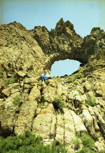
The first thing you notice about Ash Meadows is that it doesn’t look much different from the rest of Southern Nevada. You see acres of gently rolling hills, occasionally populated by sagebrush, juniper trees, and mesquite bushes. But upon closer look you’ll find there’s much more to Ash Meadows.

In fact, this little pocket of rural Nevada boasts the greatest concentration of endemic species in the United States. Some 24 different species of plants, fish, and animal life are only found at Ash Meadows.

The Ash Meadows refuge, which encompasses about 22,000 acres, was originally part of a large Amargosa Valley alfalfa ranch, which was later used for cattle ranching.

In 1984, the nature conservancy purchased a portion of the ranch to prevent it from being further developed. A few years later, the area was designated a national wildlife refuge and came under the management of the U.S. Fish and Wildlife Service. In 1994, a small part of the wildlife refuge, the site of a natural area known as Devil’s Hole, was made part of the Death Valley National Park.

One of the main reasons that Ash Meadows was made into a nature preserve was because of the presence of a tiny creature known as the Devil’s Hole pupfish. This inch-long, nearly transparent fish can only be found at Devil’s Hole, which is a deep, narrow crevice in the ground that is filled with natural spring water.

This small body of water is the only place in the world that the devil’s hole pupfish proliferates. About 90 percent of this endangered species lives within 20 feet of the water’s surface and spawn on a submerged rock ledge.

Ground water usage in the surrounding Amargosa Valley is strictly regulated to ensure that the water level in Devil’s Hole doesn’t drop below the level necessary to support the pupfish population. Scientists believe the springs throughout the valley are linked so that any change in the water table, such as that caused by excessive groundwater pumping, can have an adverse effect on the pupfish.

The reason so many springs are clustered at Ash Meadows is that it is a major discharge point for a large underground aquifer, believed to stretch nearly 100 miles to the northeast. Apparently, a prominent geological fault at Ash Meadows blocks the underground flow of the aquifer and forces the water to the surface. Because this water is thought to have entered the ground thousands of years ago, it is known as “fossil water.”

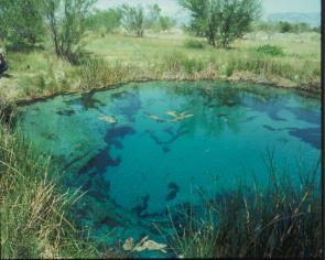
The Devil’s Hole pupfish isn’t the only unique species of fish found at Ash Meadows. On the refuge you can find about a half-dozen spring-fed pools, and nearly each has its own one-of-a-kind species.

For example, the Ash Meadows Amargosa Pupfish thrives in a warm water pond called crystal springs while the Warm Springs Pupfish is only found in a pond known, not surprisingly, as Warm Springs. Additionally, at Jackrabbit Spring, you’ll spot the endangered Ash Meadows speckled dace, another type of tiny fish.

Each pool is believed to have once been part of a larger body of water that eventually receded into smaller, separate ponds. Over time, subgroups of pupfish evolved, each genetically different from the others.

Walking through the refuge is a peaceful experience. A few hundred yards from the dirt road leading into the refuge, it’s not uncommon to spot small herds of wild horses and wild burros foraging in the area.

A short walk from the main parking area leads you to crystal spring interpretive boardwalk. This wooden walkway allows you to safely view some of the unique plants found at Ash Meadows, such as the threatened Ash Meadows Ivesia and the Ash Meadows Gumplant.

The boardwalk also provides a platform for viewing crystal spring, which is so-named because of its sparkling, inviting, clear blue waters. Standing on the grassy edge of the warm, spring-fed pond, which is about the size of a typical backyard swimming pool, you can see small bubbles rising from somewhere below.

It you look closely into the water, which is about 85 degrees, you can see the tiny pupfish swimming around a submerged rock ledge, looking like tiny, silvery, nearly see-through sardines. It is kind of humbling to look at these little fish darting through the water and realize that they represent all the members of their particular species in the entire world.

Ash Meadows is home to seven species of plants that are either endangered or threatened, including the Amargosa niterwort, the Ash Meadows milk-vetch, and the Ash Meadows sunray. The Ash Meadows naucorid, a water-based beetle, is also on the list of threatened insects.

239 different species of birds have been sited at the refuge, including endangered falcons and bald eagles, which makes it popular for bird watching the best time of year to spot birds is during the spring and fall migrations.

Among the remnants of the old cattle ranch that was once on the site of the refuge are two large, manmade lakes, fed by overflow from some of the springs. At one of them, Crystal Lake, swimming is allowed.

The long-term goal of the wildlife service is to remove any unnecessary roads and buildings as well as the more than 100 non-native plants and animals that were introduced into the region by past development.

For more information about the Ash Meadows National Wildlife Refuge, call 775-372-5435.

Friday, October 13, 2006

Driving Over Scenic Hinkey Summit


Years ago, a friend told me about a nice, little scenic road that passed through the heart of the Santa Rosa Mountains in Northern Nevada.

After driving the route, known as the Hinkey Summit Drive, I can say he undersold the road. Hinkey Summit Road is one of the most spectacular drives in the state.

It begins just beyond the quaint and picturesque community of Paradise Valley, on the eastern side of the Santa Rosa Range, about 45 miles north of Winnemucca.

The first few miles of the drive are not particularly noteworthy. You drive on a graded gravel-dirt road through a flat, dry high desert valley. Soon, however, you start to climb into the range via a fairly winding route.

The terrain gradually changes from piñon and sagebrush to rolling hills covered with wildflowers (and, of course, more sagebrush). While it’s best to have a high clearance, four-wheel drive vehicle, the road isn’t particularly rough or difficult, just a bit bumpy.

Along the way, you pass a handful of small cabins and homes tucked into little side canyons. These are private residences, most used during the summer months.

A mile or so up the road, you begin to see a couple of the range’s impressive granite peaks. Just ahead is a craggy, rock mound, its rough, gray surface resembling elephant skin.

Soon, we spotted one of the most remarkable sights on the drive—a mountain slope thickly covered with blooming, yellow mule ear flowers. This combination of vivid green, gray and yellow colors seemed painted on the landscape.

The road continues to climb and the mountain peaks grow even more scenic. To one side, we viewed a virtual wall of jagged mountaintops, some still covered with small patches of white snow.

We stopped here to enjoy the view, delighting in the unspoiled beauty of these mountains. To the west, we could see Granite Peak, one of the taller peaks in the range with an elevation of 9,732 feet.

A bit farther, at Hinkey Summit, we came upon one of the most amazing geological features of the drive—a large, round hole in one of the mountains.

Measuring perhaps 30 to 50 feet across, the hole, which apparently has no name, is angled slightly so that when you stand below it you look up into the deep blue sky.

We stopped to explore the hole; my teenage son climbed to a rock ledge at its base so I could take his photo. The rocks and the opening, which is almost a perfect circle, are fractured in such a way as to resemble a large stone bulls-eye.

Opposite the hole in the mountain are a handful of buildings, which are the Martin Creek Guard Station. A bit up the road from the guard station is the Lye Creek Campground, which has 13 developed campsites and a large group picnic area.

Several spring-fed creeks can be found running through the campground, which is generally open June through October.
From here, the road slowly begins to wind down the western slope of the range. A few miles from Hinkey Summit you reach a series of narrow, sharp switchbacks known as Windy Gap.

When you finally reach the base of the gap, the road flattens out and continues west to U.S. 95. Along the way, you will pass the ruins of an abandoned mining mill site, which appears to date to the mid-20th century.

It’s a fairly quick drive to the highway, which leads south to Winnemucca or north to McDermitt and the Oregon border.
The Hinkey Summit Drive offers a unique opportunity to travel through the remote and uncrowded Santa Rosa Mountains, among Nevada’s less well-known natural treasures.

For more information about the area, contact the Santa Rosa Ranger District, 1200 Winnemucca Blvd. East, Winnemucca, NV 89445, 775-623-5025, ext. 24, www.fs.fed.us/htnf/santarosawelcome.htm.

Tuesday, October 10, 2006

Hot Times at Diana's Punchbowl


For years, I’ve wanted to see the geological oddity known as Diana’s Punchbowl; also known at the Devil’s Punchbowl or the Devil’s Cauldron. I’d looked at photos depicting this wide, deep hole filled with scalding hot water and wanted to see if for myself.

Recently, I got my wish. While traveling through Central Nevada with the Wild Nevada TV show, I noticed that our planned route through the Monitor Valley would take us by Diana’s Punchbowl. After a bit of cajoling, the crew agreed to check out this geothermal phenomenon that had so gripped my imagination.

As we traveled along a dusty, unpaved road in the center of the valley, we could see the distinctive site from many miles away. Diana’s Punchbowl is located atop a massive travertine hill that is quite noticeable because it is nearly white.

We turned onto the road leading to the mound, which measures about 600 feet in diameter, stopping at the base of the rise. We parked and began the short climb to the top.

Then, there it was—Diana’s Punchbowl. The bowl is actually a big hole in the top of the hill. The opening measures about 50 feet across.

Inside are steep, nearly vertical walls that drop down about 30 feet to a small geothermal pool filled with water that is said to be 200-degrees (Fahrenheit) hot and reportedly exhales hot vapors and gases as well as steam.

As I cautious crept closer to the edge, I could see there is a small, grass-covered ledge inside of the bowl. Amazingly, some irresponsible and stupid souls have somehow climbed inside of the bowl and left graffiti markings on the interior walls.

As I stood at the top, looking down into the blue-green waters, I was impressed by the size and appearance of this geological marvel. It had been worth the effort to get there.

While it’s difficult to find much written about Diana’s Punchbowl, it appears to have been created when the top and center core of this limestone hill collapsed, leaving behind the large, water-filled opening.

The origins of the punchbowl’s name vary. Helen Carlson’s “Nevada Place Names” book implies that the name came from Diana, the Roman goddess of springs and brooks.

According to Phillip I. Earl, former curator of history at the Nevada Historical Society, the site has been known to native peoples in the region for thousands of years and to local ranchers since their arrival in the 1860s.

Earl has written that the Native Americans viewed the punchbowl as the home of great spirits, lost souls, and mysterious creatures.

He noted that one particularly common story surrounds the tossing of an unfaithful husband into the steaming, hot bowl by his unhappy wife—although there’s also a version of the story that has a jealous husband dropping his wife (named Diana) into the hot water after suspecting her of infidelity.

According to Earl, the first tourists to visit the site were probably local folks from nearby Belmont, Austin or Tonopah, who would picnic on the mound’s slopes and enjoy the views.

Earl has also written that a bottle thrown into the bowl’s hot waters will break as it touches the surface—but please don’t try it because littering is against the law.

In the end, the best thing about Diana’s Punchbowl is that it exists. It’s one of those unusual Nevada places that help to define what makes the state so special.

And I’m glad I finally got to see it.

Diana’s Punchbowl is located about 35 miles south of U.S. 50 via a dirt road that is 13 miles east of the Hickison Summit Rest Stop. For more information go to www.bigsmokyvalley.com/places_to_see_sv.htm.

Thursday, October 05, 2006

Journeying to Nevada's Miniature Grand Canyon


There really is a place in Nevada called the “Miniature Grand Canyon.”

While the name is perhaps a bit of hyperbole, the site is noteworthy for being one of those hidden, largely unknown scenic gems that occasionally can be found in remote parts of the state.

In this case, the Miniature Grand Canyon is located high in the Monitor Range on the east side of the Monitor Valley in Central Nevada.

I discovered the Miniature Grand Canyon last year while researching potential trips for Reno public TV’s “Wild Nevada” program. The show’s former producer, Jack Kelly, and I were studying maps of the Monitor Valley and spotted the intriguing name on an atlas map.

We checked around to see if anyone had ever been there and discovered from a National Forest Service staffer that it was, indeed, a real place. Our informant, who had been there, said it was quite lovely but small, hence the name.

So, we headed out to the wilds of remote Central Nevada to find this lilliputian landmark. To reach the Monitor Valley, we headed east on U.S. 50 to Austin (about 171 miles from Carson City), then continued east for another 35 miles to a dirt road on the south side of the highway.

We turned onto the dirt road, which is in fairly good shape, and continued south through the center of the Monitor Valley. After driving for about an hour and half, we turned onto a road heading east and climbed into the Monitor Range to find the Miniature Grand Canyon.

Since there aren’t any road signs indicating exactly how to reach the canyon, consult a good road atlas such as the Nevada Road & Recreation Atlas by Benchmark Maps.

The road wound through juniper and piñon forests before finally reaching the site. Coming from the west, we encountered a wide, fairly steep box canyon that opened up adjacent to the road. A small wooden sign indicated that it was the Miniature Grand Canyon.

While this spot was pretty, it only served as an appetizer for what was below. We decided to climb down the hillside, below the sign, and entered the canyon from the west side. This involved wandering through clumps of juniper trees, then crossing a couple of expanses of loose, shale-like rock to reach the canyon opening.

A small creek ran from the canyon mouth, so we followed it through thick underbrush for a couple of hundred yards before encountering the truly best part of the canyon. Here, the canyon narrowed into a small (only about a 100-feet wide) opening with steep vertical walls of perhaps 50-feet.

The creek trickled from above, and we could see that when it had more water (in the Spring or early summer) it fell over two or three rock benches, which created a small series of waterfalls.

Inside this opening in the canyon’s moist rock walls, there were patches of lush vegetation. The result was that the place seemed like a tiny Garden of Eden, with its green grasses, mosses and shrubs growing amidst the trickling waterfalls.

After making this discovery, we wondered what it looked like from above, so we returned to the road, and then hiked to the spot from above. From there, we could see that over many, many centuries the small creek had carved a steep channel through the rock walls, including the opening at the mouth of the canyon.

The process, in fact, had been similar to the way in which the real Grand Canyon had been formed.
So, it really was a Miniature Grand Canyon. And without the crowds.

The "Sump"—Strange Name but Amazing Place


The Sump

Years ago, a woman from Goldfield told me about a place in central Nevada that she said deserved to be a state park. She described it a geological wonderland with stumps of petrified wood, beautiful eroded cliffs and unusual clay spires and other formations.

She called this place the “Sump.” Since my dictionary defines a sump as a pit, cistern, or cesspool for draining liquid—I didn’t exactly rush out to find it.

My mistake.

The Sump is one of those hidden treasures you occasionally stumble upon when exploring Nevada. It doesn’t show up on many maps (it’s not on the official state highway map) and it’s not mentioned in any of the major Nevada guidebooks.

In fact, the best directions for reaching the Sump appear in a recently published rock-hunting guide, “Rockhounding Nevada,” by William A. Kappele (Falcon Publishing, 1998).

But despite its obscurity, the Sump is worthy of a visit should you find yourself traveling on U.S. 95 between Hawthorne and Tonopah. Keep in mind, however, that you’ll need a high clearance vehicle, preferably with four-wheel drive, to make this trip.

To reach it, head south of Hawthorne on U.S. 95 to the Coaldale Junction. Drive west on U.S. 6 for about six miles, then turn south on State Route 773. Continue 10 miles before turning left on a dirt road (if you reach the intersection of 773 and State Route 264, you’ve gone about four-tenths of a mile too far).

Head about a half-mile to a wide wash, then carefully drive into the wash (there is a steep drop), which can be sandy in places. Turn left and continue about 1.5 miles to the lower end of the Sump.

From this spot, you can walk into the Sump and begin exploring this bizarre, otherworldly landscape. Geologically speaking, the Sump began to form about 25 million years ago. At that time, a vast, prehistoric body of water named Lake Esmeralda covered the region.

Over time, sediment was carried into the lake by streams and creeks. This mud eventually hardened into multi-colored layers. Later, the area experienced volcanic activity and the sediment became covered with volcanic ash.

Intense geologic forces uplifted the region, creating the current mountain ranges near the Sump (the Volcanic Hills and the Silver Peak Range). During the last two million years, additional volcanic eruptions further shaped the landscape with basalt flows and pumice eruptions.

In the last couple dozen millennia, the main influence on the Sump has been erosion. The wind, snow, and rain have carved the sedimentary rock into tall twisted columns, smooth mounds, and rippled, curtain-like rock walls. Wandering its mile-and-a-half length, I found myself comparing it favorably to Cathedral Gorge State Park in Eastern Nevada.

Additionally, the Sump contains the remnants of a grove of petrified trees. In most cases, these tree stumps stand on mounds of solidified mud, surrounded by tens of thousands of brown chips (from a distance the mounds actually look like piles of wood chips).

Apparently, these smooth brown rock chips are examples of incomplete petrified wood; the cellular replacement of the wood with silica (the process of creating petrified wood) was not completed. As a result, the Sump’s petrified wood doesn’t have the grain texture or hardness usually associated with the better examples of petrified wood.

Deeper into the wash, near the northeast end of the Sump, you can also find white petrified wood twigs and casts littered around the ground. While small, they are interesting, nonetheless, because you can actually see the wood grain in the rock fragments.

Exploring the rest of the gorge, you can find plenty of other types of rocks. Not being a rock hound or a geologist, I wasn’t certain what we were finding but did see some nice red rocks (perhaps jasper?) as well as beautiful greenish stones (copper?) and plenty of small white and rose quartz pieces.

But interesting rocks aside, the best thing about the Sump is its mood and ambience. Climbing around its bizarre rock mounds and formations, scanning a landscape that has remained so unchanged by man, it’s easy to believe you’re the first person to ever see the place.

Until you notice the old ATV tracks in the center of the wash.

Wednesday, October 04, 2006

Toquima Cave Offers Glimpses of Rare Pictographs


Toquima Cave

While I’ve been fortunate enough to have traveled a good deal of the state of Nevada during the past couple of decades, there are still plenty of places I’ve never had the pleasure of visiting such as Toquima Cave.

Located in Central Nevada, Toquima Cave is an archaeologically significant site that contains prehistoric pictographs, which are painted symbols, designs and patterns. Pictographs are similar to petroglyphs, which have been carved into rock rather than painted.

Archaeologists aren’t quite sure how to interpret either of them but it is generally believed that Native American people, who may have been the ancestors to today’s Nevada tribes, created the drawings and carvings.

Part of the reason I’d never made it Toquima Cave is that it’s located in a fairly remote part of the state. It sits high in the north section of the Toquima Range and is accessed via a four-wheel drive dirt road that leads over the mountains from the Big Smoky Valley to the Monitor Valley.

To reach the cave, travel about 14 miles east of Austin on U.S. 50 to the point where it intersects with State Route 376 (the road to Tonopah). Turn south on 376, then after about a tenth of a mile, take an immediate left onto a dirt road (marked by an historical marker for Toquima Cave).

Continue for about 15 miles across the valley and head into the mountains. At a place known as Pete’s Summit, you’ll reach the Toquima Caves Campground (it is marked with large forest service signs). Park near the campgrounds, then hike about a quarter of a mile on a marked trail to the cave.

Of course, the cave is difficult to reach at this time of year, so plan your visit during the summer or fall months.

The hike to the cave winds through a forest of scruffy piñon trees. The trail gradually climbs to a large red colored rock outcropping, where the cave is located. You’ll know you’ve found it when you spot the tall, metal fence across the mouth of the cave.

To protect the cave, an imposing 10-foot-high cyclone-style fence blocks access. Unfortunately, the National Forest Service doesn’t have the resources to staff the area around the clock so the fence helps keep vandals out.

Despite the fence, it is possible to look into the cave to see the pictographs. As someone who had never seen these kind of markings, I found myself fascinated by the various shapes and colors. Painted all over the rock walls inside the cave where strange round shapes as well as various types of squiggly and straight lines.

I was most impressed by the colors. I had been expecting black charcoal markings but saw drawings painted in bright red, yellow, white and black.

As I stared at the painted symbols, they began to take on familiar forms. A couple of lines and circles became a stick figure of a deer or elk. Another cluster of lines seemed to look like an elephant—although elephants never lived in Nevada—or maybe it was a bison.

The sheer number of pictographs surprised me—there seemed to be dozens drawn all over the cave walls.

In my mind, I began to speculate about what they meant. Maybe they told stories or passed on some kind of information from one generation to the next. Perhaps they were just cave graffiti or represented some kind of record-keeping system. And I wondered why they came to such an out-of-the-way place to just scribble on the walls. We’ll probably never know for sure.

I turned away from the fence and looked back over the surrounding landscape. The view of the valley and the trees was spectacular. Then it hit me. Maybe those ancient people came to the cave simply because it was a cool place to hang out. It seemed like as good a reason as any.

The Toquima Cave Campground is open from May to November. It has only six sites; two with picnic tables. One of the sites has a fire pit with a grill while the others have fire rings. There is a unisex toilet near the campground but no water or garbage facilities, so you’ll have to bring any food and water you’ll need (and pack all your garbage out with you).

For more information about Toquima Cave contact the USDA Forest Service, Tonopah Ranger District, www.fs.fed.us/htnf/tonopah.htm.

Monday, October 02, 2006

Finding Traces of Nevada's First People


Hickison Summit Petroglyphs

Sometimes it can be worthwhile to revisit a place where you’ve been before. That was the case when I recently stopped at the Hickison Summit area off U.S. 50, located about 25 miles east of Austin.

I’d been to Hickison Summit, which is a Bureau of Land Management rest area, on several previous occasions. But on this particular visit, I was able to spend a little more time at the site and discovered that I had only seen a portion of what is found there.

The site is located about a mile off the highway via a graded dirt road. At first glance, it appears to be little more than a couple of picnic tables tucked into a forest of bushy piñon pine trees enclosed in a canyon.

However, if you walk along the marked, interpretive trail, you quickly find that this is a site rich with ancient petroglyphs, which are prehistoric rock carvings.

On my earlier stops, I had seen a handful of the stone etchings along a sandstone cliff directly southwest of the parking lot. This time, I studied the rock walls more closely and discovered dozens more horseshoe-shaped carvings as well as various squiggles, circles and patterns etched into the stone.

While the exact meaning of these carvings isn’t known, many archaeologists believe that the Hickison Summit glyphs represented fertility. Additionally, in some places, the symbols seem to suggest the seasons and elements, particularly the sun.

The trail leads to the opposite side of the canyon, where, if you look closely at the walls, you can find additional rock symbols carved high in the stone (look up).

During my previous visits, I had also not noticed that there are petroglyphs carved into several large stone boulders near the picnic area. These include writing that resembles some kind of multiple-legged creature as well as intricate grid-style patterns.

In addition to the rock art, the Hickison Summit site in the Simpson Park Mountains, also features exceptional scenery (perhaps that's what really attracted those early people who carved the petroglyphs).

A short trail leads to the top of a rise behind the canyon and a scenic overview spot that offers a great view of the surrounding area.

Indeed, the rugged, picturesque cliffs and thick piñon grove, located at about 6,500-feet, make it a cool, shaded place to relax before tackling the rest of Highway 50, the “Loneliest Road in America.”

As a Bureau of Land Management recreational area, the Hickison Summit site also includes restrooms and a half dozen, day use picnic tables.

For those wanting to camp (in the warmer months), check out the Bob Scott Campground, located about 15 miles west of Hickison Summit on Highway 50 (10 miles east of Austin). This Forest Service area includes 15 campsites in piñon trees as well as picnic tables and drinking water. There is a fee for overnight camping.

For more information about the Hickison Summit area and other central Nevada attractions contact the Bureau of Land Management, Battle Mountain District Office, 50 Bastian Rd., Battle Mountain, NV 89820, 775-635-4000.

Sunday, October 01, 2006

Story of Soda Lake is Deeper Than You Might Think


Soda Lake

While Soda Lake near Fallon may look like a typical desert lake, there is much more to its story.

Not truly a natural body of water, Soda Lake was created by several factors, including the presence of natural springs, a rising water table caused by irrigation of the area and the effects of mining its depths for soda, which started in the 1850s.

In fact, in recent years the lake's historic significance has some folks talking about designating the lake as a park or putting it on the National Register of Historic Places.

Soda Lake is located about 55 miles east of Carson City via Highway 50 and Soda Lake Road, a marked paved street that is five miles west of Fallon.

Geologically speaking, the Soda Lake basin was created by a collapsed volcanic cone. The outline of the cone can best be seen on the east side of the lake, which rises high above the water. Additionally, rock hounds can find plenty of stones that are volcanic in origin on the ground around the lake.

In the 1840s, pioneers crossing the nearby 40-mile desert stumbled upon the lake as well as the natural springs adjacent to it, which were the first fresh water to be found after crossing that dreaded stretch of desolate landscape.

In the mid-1850s, several claims were filed on the lake because of the presence of extremely pure soda, which could be used in the mining operations on Virginia City's Comstock Lode.

Starting in 1875, commercial soda extraction operations commenced on the lake and two major soda works were constructed on the edge of the lake, making it one of the west's first commercially viable soda producing areas.

Records indicate that soda from the lake was of such quality that it won a gold medal at the 1876 Centennial exposition in Philadelphia.

Ironically, the completion of the Newlands Water Project in 1915, which helped spur the development of the surrounding Lahontan Valley as an agricultural and ranching oasis, marked the beginning of the end of Soda Lake's namesake business.

Irrigation water from the massive aqueduct system, which brought water to the desert valley from the Carson and Truckee rivers, percolated into the groundwater and caused the lake level to rise.

Within a few years, the soda plant was submerged, an occurrence that resulted in several lawsuits, including a landmark legal decision, which stated that the U.S. Government could be absolved from damages as a result of "unintentional" actions committed by one of its agencies.

In the end, the lake level rose from 147 feet to more than 200 feet, leaving the soda works under some 35 feet of water.
As a result of being under water, the soda works structures have remained well preserved. Over the years, the lake has become popular with divers who can swim through the relatively intact ruins of the old soda plant and other buildings.

Additionally, divers report the presence of a "ghost forest" at the southeastern end of the lake, which is believed to be the remains of a grove of cottonwood trees.

Photos of the soda works and trees are on display at the nearby Churchill County Museum in Fallon and depict a mysterious, murky underwater world filled with strange shapes and shadows.

Because of its undeveloped nature—submerged soda factory notwithstanding—the lake has become a sanctuary for a wide variety of birds. Visitors can often spot flocks of gulls, terns, ducks and other waterfowl enjoying the peace and calm of this half-hidden lake.

The lake also boasts a population of brine shrimp and underwater plants that have adapted to the high alkali content of the water.

For more information about Soda Lake, contact the Churchill County Museum, 1050 S. Maine St., Fallon, NV 89406, 775-423-3677, www.ccmuseum.org.

Permanent Wave Society Brings Amusing Art to Great Basin Visitors

  Anyone traveling on State Route 488, the road that leads from the tiny eastern Nevada town of Baker to Great Basin National Park, will qui...