The Sump
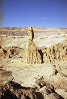
Years ago, a woman from Goldfield told me about a place in central Nevada that she said deserved to be a state park. She described it a geological wonderland with stumps of petrified wood, beautiful eroded cliffs and unusual clay spires and other formations.
She called this place the “Sump.” Since my dictionary defines a sump as a pit, cistern, or cesspool for draining liquid—I didn’t exactly rush out to find it.
My mistake.
The Sump is one of those hidden treasures you occasionally stumble upon when exploring Nevada. It doesn’t show up on many maps (it’s not on the official state highway map) and it’s not mentioned in any of the major Nevada guidebooks.
In fact, the best directions for reaching the Sump appear in a recently published rock-hunting guide, “Rockhounding Nevada,” by William A. Kappele (Falcon Publishing, 1998).
But despite its obscurity, the Sump is worthy of a visit should you find yourself traveling on U.S. 95 between Hawthorne and Tonopah. Keep in mind, however, that you’ll need a high clearance vehicle, preferably with four-wheel drive, to make this trip.
To reach it, head south of Hawthorne on U.S. 95 to the Coaldale Junction. Drive west on U.S. 6 for about six miles, then turn south on State Route 773. Continue 10 miles before turning left on a dirt road (if you reach the intersection of 773 and State Route 264, you’ve gone about four-tenths of a mile too far).
Head about a half-mile to a wide wash, then carefully drive into the wash (there is a steep drop), which can be sandy in places. Turn left and continue about 1.5 miles to the lower end of the Sump.
From this spot, you can walk into the Sump and begin exploring this bizarre, otherworldly landscape. Geologically speaking, the Sump began to form about 25 million years ago. At that time, a vast, prehistoric body of water named Lake Esmeralda covered the region.
Over time, sediment was carried into the lake by streams and creeks. This mud eventually hardened into multi-colored layers. Later, the area experienced volcanic activity and the sediment became covered with volcanic ash.
Intense geologic forces uplifted the region, creating the current mountain ranges near the Sump (the Volcanic Hills and the Silver Peak Range). During the last two million years, additional volcanic eruptions further shaped the landscape with basalt flows and pumice eruptions.
In the last couple dozen millennia, the main influence on the Sump has been erosion. The wind, snow, and rain have carved the sedimentary rock into tall twisted columns, smooth mounds, and rippled, curtain-like rock walls. Wandering its mile-and-a-half length, I found myself comparing it favorably to Cathedral Gorge State Park in Eastern Nevada.
Additionally, the Sump contains the remnants of a grove of petrified trees. In most cases, these tree stumps stand on mounds of solidified mud, surrounded by tens of thousands of brown chips (from a distance the mounds actually look like piles of wood chips).
Apparently, these smooth brown rock chips are examples of incomplete petrified wood; the cellular replacement of the wood with silica (the process of creating petrified wood) was not completed. As a result, the Sump’s petrified wood doesn’t have the grain texture or hardness usually associated with the better examples of petrified wood.
Deeper into the wash, near the northeast end of the Sump, you can also find white petrified wood twigs and casts littered around the ground. While small, they are interesting, nonetheless, because you can actually see the wood grain in the rock fragments.
Exploring the rest of the gorge, you can find plenty of other types of rocks. Not being a rock hound or a geologist, I wasn’t certain what we were finding but did see some nice red rocks (perhaps jasper?) as well as beautiful greenish stones (copper?) and plenty of small white and rose quartz pieces.
But interesting rocks aside, the best thing about the Sump is its mood and ambience. Climbing around its bizarre rock mounds and formations, scanning a landscape that has remained so unchanged by man, it’s easy to believe you’re the first person to ever see the place.
Until you notice the old ATV tracks in the center of the wash.


I'd been to Nevada but I never get the change to go here. Truly a wonderful place as you said.
ReplyDeletedenver commercial maintenance
Its a surreal landscape, uneven and bizzare. You must experience it firsthand. Even photos do not do it justice.
ReplyDelete