Monday, June 27, 2022

Great Basin National Park's Often-Overlooked Osceola Ditch Trail


   Few visitors to Nevada’s Great Basin National Park notice the sign indicating the trailhead for the Osceola Ditch Interpretive Trail—which is a shame because there’s a fascinating story behind the ditch as well as the town to which it once provided water.

   The interpretive trail can be found about 4.6 miles from the start of the Wheeler Peak Scenic Road. A sign notes the trail location, with parking on the right side of the highway.

   While today little remains of the actual ditch, in the late 19th century it was an engineering achievement. Gold was discovered in about 1872 in what would become known as the Osceola Mining District (which is located three miles west of Great Basin National Park; accessible by dirt road from U.S. 50 at the Sacramento Pass Recreation/Rest Area).

   Prospectors James Matteson and Frank Heck made the initial gold ore discovery and within a short time other miners poured into the area seeking to make their fortunes. Within two years, Osceola had 250 residents and by 1882 a town of about 1,500 people had sprouted on the northwest side of Mount Wheeler.

   Since there weren’t any major sources of water near the mining district, which was located in a deep ravine, the miners decided to construct a 16-mile ditch to drain water off the western slope of the South Snake Range.

   This ditch, completed in 1885, cost more than $80,000 to build and employed more than 175 workers. The water from the ditch (called the West Ditch) allowed a limited hydraulic mining (essentially blasting the ravine with pressurized water to free up any gold) and inspired the miners to build a second ditch to bring even more water to the area.

   This second canal, which was 18 miles long, was designed to carry water from streams located to the southeast, including Lehman Creek. This water system, built between 1889-1890, cost more than $108,000 and involved some 300 workers, many of whom were Chinese or local Native Americans.

   The second (or East) ditch (part of which is today’s Osceola Ditch Trail) required constructing miles of wooden flumes as well as blasting a 600-foot tunnel through rock outcroppings.

   Adding the second canal ultimately didn’t substantially improve the haul from Osceola’s mines. Additionally, several dry winters in a row meant very little water was available to divert to either of the ditches.

   By 1900, the whole ditch project was abandoned. Today, the Ditch Trail retraces the path of the old flume and passes a tunnel that had to be blasted in the rock at one spot.

   Despite the ditch’s apparent lack of success, Osceola was a fairly productive (generating about $2 million) and relatively long-lived mining camp. In 1877, one of the world’s largest gold nuggets was discovered at the Osceola site, a chunk of ore weighing 24 pounds.

   Little remains of the former town of Osceola, which once boasted two stores, a hotel, a Chinese restaurant, livery stable, post office and several saloons. Visitors can still find the stone walls of the former general store, a handful of wooden structures and, on the roadside hill west of the town site, a fairly impressive cemetery.

   Much of the site is on private property—mining has been done sporadically over the years—so be courteous and respectful of the property owners.

   For more information, go to the National Park Service web site, www.nps.gov/grba/historyculture/the-osceola-ditch.htm, or to the Exploring Great Basin website, https://www.exploringgreatbasin.net/?q=content/3-osceola-ditch-interpretive-trail.

Wednesday, June 15, 2022

Santa Rosa's Burbank Gardens Offer Tranquility and History

  Tucked into a half-acre lot in the heart of the Northern California city of Santa Rosa is a picturesque city park that celebrates the life and works of renowned botanist and horticulturalist Luther Burbank, who is credited with introducing more than 250 new varieties of fruit.

  Known officially as the Luther Burbank Home and Gardens, the park at the corner of Santa Rosa and Sonoma Avenues, commemorates the life of a man largely forgotten today, but, during his lifetime, was often referred to as “the Plant Wizard” because of his efforts to create new and better varieties of fruits.

  Burbank was born in Lancaster, Massachusetts in 1849 and from an early age showed a fascination with plants. In 1867, following his father’s death, Burbank used his inheritance to purchase a 17-acre farm, where he developed what became known as the Burbank potato, a variety that was more resistant to the blight that had wiped out potato harvests all over the world.

  He sold the rights to the Burbank potato and used the proceeds to relocate to Santa Rosa, California, where he purchased a four-acre lot and built a greenhouse, nursery and experimental crop fields, where he could work on developing new varieties of plants using crossbreeding.

  To market his discoveries, Burbank published regular plant catalogs, including his famous 1893 “New Creations in Fruits and Flowers,” and marketed his new species.

  That same year, Clarence McDowell Starks, co-owner of one of the nation’s largest orchard companies, agreed to pay Burbank $9,000 in return for the rights to three of his new fruit varieties. Burbank said the arrangement finally helped make his life’s work profitable.

  As Burbank’s fame grew, so did his access to grant funding, including from the Carnegie Corporation. Over the years, he became friends with many of the era’s most acclaimed inventors and businessmen, including Henry Ford and Thomas Edison.

  Burbank died in 1926 of heart failure. He was buried beneath a large Cedar of Lebanon tree in his gardens.

  Following Burbank’s death, his wife, Elizabeth, lived in the cottage on the garden property (until her death in 1977) and, over time, disposed of his assets and patents. In the 1970s, the property was acquired by the City of Santa Rosa and converted into a public park.

  Visitors to the site today will find a peaceful, picturesque setting with rows, plots and hedges of various fruits, vegetables, and other plants. Among the unique plants found on the site are a “multi-grafted apple tree,” which Burbank used in his grafting experiments. The tree has more than 50 separate cultivars grafted onto it, including fresh-eating and cider apples.

  Additionally, there is a garden devoted to medicinal herbs, which Burbank experimented with and improved upon, a giant cactus plant, various prune and apple trees, flowers, shrubs and a host of other plant species.

  The property also has the cottage that Burbank lived in for many years (and, later, was the home of his wife) as well a brick-and-glass greenhouse, a large barn and other smaller storage buildings.

  A virtual tour of the cottage can be found on the park’s website or on Youtube, https://www.youtube.com/watch?v=Bh3x9sbimHc&feature=emb_logo.

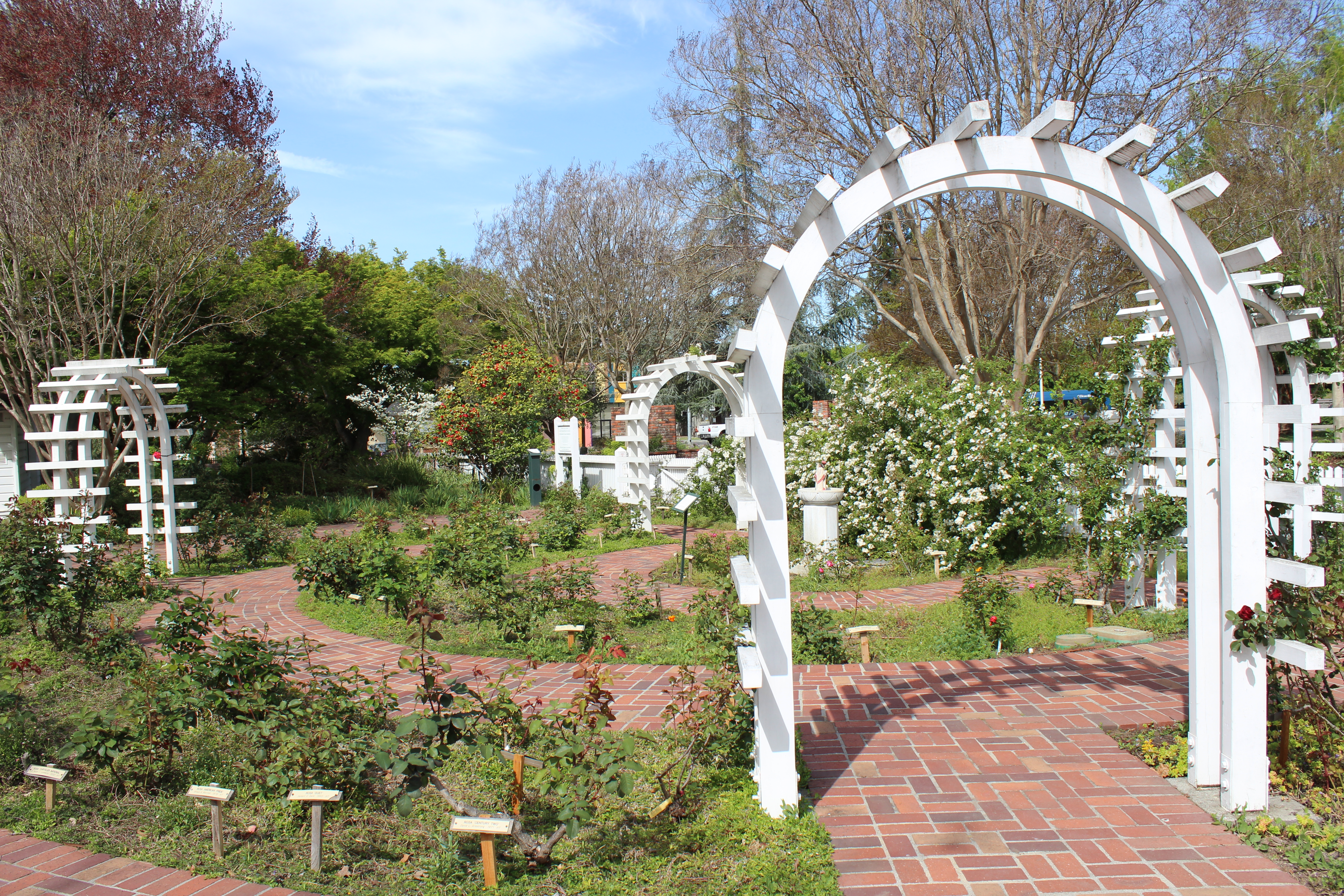
  At the entrance to the park is a brick walkway leading to a scenic fountain and wooden trellis covered with plants, while to the north end, past the barn, is a beautiful rose and flower garden with white, wooden arches.

  Entry into the park, open to the public on Sunday, Monday, and Wednesdays from 8 a.m. to dusk, and Tuesday, Thursday, and Saturdays from 1 p.m. to dusk, is free. Tours, the small museum and gift shop are available Tuesday through Sunday, 1 p.m. to 4 p.m.

  For more information, go to: http://www.lutherburbank.org/.


Friday, June 03, 2022

The Founding of Reno's Rancho San Rafael Park

  Any study of the effort to create Reno’s Rancho San Rafael Park must begin with Clark Santini.

  The brother of former Nevada Congressman Jim Santini and nephew of famed Nevada writer Walter Van Tilburg Clark, Clark Santini had previously worked on the successful effort to create a state park at Tule Springs in Southern Nevada.

  According to Nevada historian Elmer Rusco, who authored a 1998 study on the effort to create the park, “The Benchmarks of . . . Character and Way of Life: The Acquisition of Rancho San Rafael Regional Park,” Santini’s involvement began in 1976 when he and several friends met to discuss somehow converting the ranch, one of the last large parcels of open land in the city, into a public park.

  “Santini brought up the information that the ranch was for sale and broached the idea . . . of attempting to interest all three local government entities—Washoe County, Reno and Sparks—into jointly purchasing it as a regional park,” Rusco wrote.

  He added that after the group, which included Virginia and Bob Kersey, Rabbi Abraham Feinberg and Patricia Blanchard, agreed to push ahead with the idea, Santini, who passed away in 1996, was designated the main spokesman for the effort and was later even called “father of Rancho San Rafael.”

  During the next three years, Santini’s group succeeded in getting legal authorization from the Nevada state legislature for a bond election to pay for acquiring the property. Additionally, with the support of former Sparks Assemblyman Don Mello, park supporters worked with Nevada’s Public Employees Retirement System (PERS) to purchase the ranch as an investment, and then sell it to Washoe County, once the bond passed.

  In the event that the bond failed, PERS would be free to sell the land to private investors, thereby recouping its investment.

  According to Rusco, in January 1979 PERS bought the 408-acre ranch for $7.5 million and agreed to sell it to the county at that cost, plus 15 percent for each year required for the transfer. The county had five years to complete the deal.

  On June 5, 1979, the bond was approved overwhelmingly, gaining nearly 62 percent of the total votes cast on the question.

  Since it was created, Rancho San Rafael Park has been expanded twice. In 1993, a land donation from the late Reno businessman William Thornton and his wife, Dr. Barbara Thornton, a longtime professor at the University of Nevada Reno, enlarged the park by another 120 acres. Five years later, the park gained another 42 acres located in nearby Keystone Canyon as a result of a land exchange.

  Interestingly, there had been several previous attempts to turn the ranch into a park. Rusco noted that in the 1940s, University of Nevada Reno President John O. Moseley attempted to persuade the ranch’s owner, Dr. Raphael Herman, to donate the property to the university.

  Additionally, the University of Nevada, Reno Land Foundation made overtures to purchase the site in the late 1960s but the efforts were unsuccessful.

  Rancho San Rafael traces its beginnings to the early 20th century, when members of the Pincolini family purchased the property in northwest Reno. The Pincolinis apparently used the land for cattle and raised potatoes.

  In 1919, the Pincolini family sold the acreage to Martin Pradere. Shortly after, much of the property was sold to Russell Jensen, who raised sheep on the land. In the mid-1930s, Norman B. and Mariana Herman, along with Dr. Raphael Herman, acquired the land, using it primarily to raise cattle.

  Many of the ranch buildings still standing in the park, including the main ranch house (now used for meetings and conferences), were constructed during the period the Hermans owned the property. The Hermans also enlarged the ranch’s size, purchasing more than 150 adjacent acres during the next few years.

  In the 1960s, Mariana Herman became the sole owner of the property following the death of her husband and his brother, and, later, agreed to sell it to PERS.

  Today, the park totals some 577 acres and is home to the Wilbur D. May Arboretum and Botanical Gardens, the Wilbur D. May Center and museum (a collection of rare and exotic artifacts) and acres of hiking trails, picnic areas, playgrounds, ball fields and lots of open space.

  Additionally, the park hosts several major annual special events including the Great Reno Balloon Race, held each September.

  Rancho San Rafael Park is located at 1595 North Sierra Street in Reno. For more information go to http://www.washoecounty.us/parks/rsrp.htm.

  And if you visit, make sure to take a moment to thank Clark Santini.


Thursday, May 19, 2022

New Book Tells Stories of Real Nevadans

  John Glionna clearly enjoys wandering Nevada. Writing for a variety of publications over the past several decades, including the Los Angeles Times and the Las Vegas Review-Journal, Glionna has sought out stories that speak to him—and his readers.  Fortunately, many of his best articles are now collected in a new book titled, “Outback Nevada: Real Stories from the Silver State,” which was recently published by the University of Nevada Press.  The book collects some 45 features spotlighting everything from “The Rural Football Team That Rarely Scores,” about the eight-man football team at the remote McDermitt Combined School, to “The Last Sheepherder,” a profile of White Pine County sheepherder Hank Vogler, who has herded sheep for more than three-and-a-half decades.  The stories are divided into five geographic sections (the North, the South, the Center, the East, and the West), with each containing seven to ten features.  In his preface, Glionna said he began exploring Nevada’s hinterlands in response to people—who didn’t know any better—saying there was nothing out there. Those hinterlands, he wrote, are “where the real Nevada lies.”  Among those appearing in the book are Nathan Robertson and Daniel Corona, the youthful mayors, respectively, of Ely and Wendover. In addition to being under 40 years old, both are openly gay.  Others profiled included Val Trucksa and Nancy Knighten, two emergency medical technicians operating in Esmeralda County, a place big in size and small in population, who wanted to retire but couldn’t find anyone to take their places, and Boyd Graham, a native Shoshone who is trying desperately to keep his people’s dying Native American language alive.  The stories reflect Glionna’s keen eye for recognizing a good story and admirable ability to write something that is poignant when it needs to be, humorous when appropriate, and always respectful of the subject.  He has sought out not only the unusual, such as Father Charles Urnick, who conducts weekly mass in the Riverside Hotel and Casino in Laughlin, and Frank Van Zant, who man who built the bizarre Thunder Mountain art project located between Lovelock and Winnemucca, to the inspirational, like historian Wendell Huffman, who is devoted to preserving Nevada’s rich railroad history, and Melissa Mevis, a former addict who is helping other addicts to stay clean in Pahrump.  As for why he likes writing about these folks and places, Glionna provided the answer: “Driving north from Las Vegas along U.S. Route 95, I don’t feel I’ve really entered the outback until I’m well north of Indian Springs, when four-lanes narrow to two, as the turnoff toward mysterious Mercury and its tall tales of green men and secret government programs.  “Only then does my mind get right, do I stretch my emotional legs and begin to unwind. I see dirt roads that jettison from the blacktop, exploding like laser beams toward the far horizon, and fight the urge to drive every one of them.”  For those who appreciate Nevada’s open space, with its majestic mountains and wide valleys, its individualistic and often quirky people, and rich, colorful history, “Outback Nevada” is something to savor and enjoy.  “Outback Nevada” is available at local bookstores and from the University of Nevada Press website at www.unpress.nevada.edu/books/?isbn=9781647790448.

Monday, May 09, 2022

The Story of the Earp Brothers in Nevada


Virgil Earp

   If one believed all the legends regarding Old West lawmen Wyatt and Virgil Earp in Nevada, he or she might think the pair personally tamed the wild and wooly mining towns of Tonopah and Goldfield—and fought every outlaw in the state.

   The reality, however, is the Earp brothers played a fairly minor role in the history and development of the twin Central Nevada communities and only one, Virgil, was ever involved in law enforcement in Nevada.

   In January 1902, Wyatt Earp, fresh from Alaska’s mining boom, arrived in Tonopah with his wife, Josie. Within a few months, he and a partner had opened the Northern Saloon and Earp was working for the Tonopah Mining Company hauling ore and supplies.

   For a very short time, he apparently worked as an appointed deputy U.S. Marshal in Tonopah, mostly serving papers to defendants in federal court cases—but never engaged with any shootouts with desperados.

   In the late summer of 1903, the restless Earp and his wife decided to leave Tonopah. He sold his investments and headed to Los Angeles to live. The two, however, returned several times to prospect around Silver Peak and other parts of Esmeralda County.

   And that’s about it for Wyatt Earp in Nevada.

   As for Virgil Earp, Wyatt’s older brother, he and his wife, Allie, arrived in Goldfield sometime in the latter part of 1904. Down on his luck and nearly broke, he took a job as deputy sheriff of Esmeralda County and also provided security at the National Club.

   Sadly, a few months after settling in Goldfield, Virgil Earp contracted a bad case of pneumonia, which he was unable to shake. On October 19, 1905, Virgil Earp died in Goldfield at age 62. At the request of his daughter, his remains were sent to Portland, Oregon and he was buried at the Riverview Cemetery.

   It is believed that Wyatt and Josie Earp may have visited Virgil and Allie in Goldfield sometime during the summer of 1904, but there is no official record of such a visit.

   Nevada State Archivist Guy Louis Rocha, who has co-authored a book on the Earp brothers in Nevada, has written: “As for Wyatt Earp, there is no end to the list of things he didn’t do in Goldfield. He didn’t tend bar there, he didn’t own a hotel or saloon there, and in fact he didn’t do much of anything there.”

   In total, the two Earp brothers spent about eight and eleven months, respectively, in Nevada—hardly enough time to accomplish everything that has been attributed to them.

   Still, the apocryphal stories about Wyatt Earp in Tonopah make for fun reading. For instance, one of the most often repeated stories involves him coming to the rescue of Tonopah attorney Tasker Oddie, who later served as Nevada’s Governor and U.S. Senator.

   In the tale, claim jumpers were digging a shaft on land owned by Oddie’s clients. In order to stop the men from continuing, the unarmed Oddie jumped into the hole. The men allegedly pulled their guns on Oddie and ordered him to leave.

   At that moment, Wyatt Earp and his saloon partner, Al Martin, came along in a wagon. The famous former lawman, who sometimes worked for Oddie, quickly sized up the situation and jumped into the hole beside his friend.

   When the claim jumpers asked who he thought he was, Earp reportedly said, “I’m Wyatt Earp,” then pointed at Martin, who had a shotgun aimed at the mine thieves. The men lowered their guns and quickly scrambled out of the hole—but not before following Earp’s orders to replace the mine location stakes they’d knocked over.

   The great Nevada mythmakers, Lucius Beebe and Charles Clegg, wrote about a remarkably similar episode occurring on a train ride. Allegedly, union thugs decided to shoot Oddie, who worked for the mining companies.

   “A walrus mustached individual in a slouch hat and neat dark suit who was lounging in the smoking room overheard two characters in an adjacent compartment planning to shoot Oddie through the partition as soon as the train got under way,” Beebe and Clegg wrote.

   “Unceremoniously, he kicked open the door of their bedroom and told them the project was ill-advised and they had better leave the train while the going was good. To their inquiry as to just who the hell he thought he was, the answer was simply, ‘Wyatt Earp.’ The assassins left.”

   To find out what really is known about the Earps in Nevada, pick up a copy of “The Earps’ Las Frontier,” by Jeffrey M. Kintop and Guy Louis Rocha or read “Wyatt Earp: Law, Order, and a Game of Chance,” which appeared in the March/April 2016 issue of Nevada Magazine.

Monday, May 02, 2022

When the Russians Came to Northern California


  An odd item that has been in the news lately because of the situation in Ukraine has been a Russian lawmaker’s apparent demand that the United States return the state of Alaska to it. The U.S. purchased Alaska from the Russians for $7.2 million in 1867.

  While the claim is ludicrous, it is true that more than a century ago Russia controlled a portion of Northern California. In the early 19th century, the Russian government cut a deal with Spain, which, at the time, had claim to the entire Western U.S. region, to permit it to have a small colony on the northern coast of California.

  The Russians were interested in the area because of its economic potential, the fact it would allow trade between Russia and Spain, and it could provide much-needed supplies to Russian colonies in Alaska.

  The short growing season in Alaska and the dangerous journey from Russia in the winter months, when supplies were most needed, caused the Russians to look south for a more year-round farming and trading base.

  In  March 1812, the Russian-American Company, a fur-trading arm of the Russian government, established Fort Ross, a small colony on the coast of Northern California, a few miles north of Bodega Bay.

  Today, a monument to those days can be found at Fort Ross State Historic Park, located about an hour and a half north of San Francisco (12 miles north of Jenner) via scenic Highway 1, which runs along the California coast.

  By September of 1812, the Russians had constructed a redwood stockade complex at Fort Ross, which included blockhouses with cannons, several log homes, storage buildings, barracks, an armory and, in 1825, a traditional Russian Orthodox chapel.

  According to history books, the name “Ross,” was derived from a then-current literary word for Russia (“Rossiia”). In fact, the settlement wasn’t built to be a military outpost but rather a commercial trading post and was generally referred to it as “Ross Office” or “Ross colony” by the Russians.

  In addition to the stockade, a number of dwellings were built outside of the walls of the complex by native Alaskans, who had traveled south with the Russians, as well as several of the indigenous Pomo Indians, who chose to work at the fort.

  By 1828, more than 200 Russians, Alaskans and Native Americans lived at the colony. Other businesses and structures also had appeared by this time, including a bakery, a cattle yard, windmill, farmhouses, gardens and orchards (which still exist).

  The colony’s value as an agricultural base was limited because of its location next to the sea. Fog, poor crop selection and pesky gophers destroyed many of the crops, so, in 1833, the Russians established three ranches farther inland, which proved more fruitful.

  Fort Ross was somewhat viable, however, in other areas of commerce such as livestock, logging, seal fur hunting and manufacturing related products (tallow candles, wool blankets, leather goods, lumber).

  Despite its modest success, the Russian-American Company decided in 1839 to abandon the colony. The primary reasons seemed to be that the seal population in the region had been mostly exhausted, and trade in manufactured goods and agriculture fell below expectations.

  Additionally, expansion into the area by American and Mexican settlers meant that Russia would have to protect its holdings—something it was ill equipped to do because of the great distance between the colony and motherland.

  In 1841, Captain John Sutter, founder of Sacramento and de facto landlord of central California, agreed to purchase the buildings and equipment of the Russian-American Company but, apparently, not the land, which was claimed by the Mexican government (which, by this time, had succeeded Spain as the region’s overseer).

  Over the next several decades, the settlement was sold several times and used as a ranch, hotel, saloon and dance hall. In 1906, the crumbling remains of the old fort were deeded to the State of California. 

  Since then, the fort has become part of the California State Park system and most of the buildings have been rebuilt and restored.

  Visitors today will find a fascinating look at one of the more interesting episodes in California's history. Wandering through the fort, you can’t help but feel it is some kind of alien presence on California soil because of its distinctive Russian architecture, particularly the chapel with two cupolas.

  A modern visitors center, located above the fort, offers informative displays and a slide show detailing the region’s Pomo population as well as Russian exploration and settlement in the American west.

  A self-guided walking tour, supported by an informational brochure, prompts you through the compound. Informative signs in each building provide detail of what you’re viewing.

  Fort Ross is open daily from 10 a.m. to 4:30 p.m. For more information, go to www.fortross.org/info.


Thursday, April 21, 2022

Before Ely—There was Lane City


  The remnants of one of White Pine County’s earliest communities, Lane City, can still be seen just west of Ely.

  In fact, Lane City, originally known as Mineral City, is considered one of the area’s first significant settlements. It was established several years earlier than Ely.

  According to Nevada historian Shawn Hall’s book, “Romancing Nevada’s Past: Ghost Towns and Historic Sites of Eureka, Lander and White Pine Counties,” a local Native American guided a prospecting party led by Thomas Robinson to promising silver deposits in the region in late 1867.

  The discovery led to the creation of the Robinson Mining District in March 1868 and within two years a small community had cropped up, which was named Mineral City.

  To process all of the silver being mined in the district, a 10-stamp mill and a small smelter were built in city, which grew to nearly 600 residents in 1872-73. According to Hall, Mineral City also had a post office, six saloons, four boardinghouses and a handful of shops and stores.

  Despite a drop in silver production, beginning in 1874, Mineral City managed to survive for several years as a regional hub for mining operations in the county.

  By 1880, however, it was clear that Mineral City’s boom had gone bust, and most of its residents began to wander off to more lucrative mining opportunities.

  The district, however, revived in 1896, when Charles D. Lane, a wealthy Eastern investor, purchased many of the local claims, reopened the stamp mill and constructed a power plant and water ditch. It was during this time that Mineral City’s name was changed to Lane City.

  During the next decade and a half, the area’s mines and mining operations sporadically operated, depending on whether enough ore could be found and processed.

  By 1910, Lane City’s mines were largely shut down for good. The post office, which had reopened in 1902, closed again in 1911.

  Because of the success of copper mining in nearby Ruth, Lane City, however, wasn’t completely abandoned as a number of miners continued to live in the community and work in the adjacent mines or in Ely.

  Throughout the first part of the 20th century, Lane City boasted about a dozen homes and a fine brick schoolhouse, which, while long abandoned, remains standing.

  Today, visitors to Lane City can find a handful of stone, frame and log buildings as well as some stone walls and foundations, all of which date to the early 20th century. It’s not believed that any of the original structures from the settlement’s earliest days (when it was still called Mineral City) still exist.

  Lane City is located three miles northwest of Ely, on the east side of U.S. 50. The ruins are accessible via a dirt road. Be aware, however, that much of the area is private property and there are some open mine diggings.

  One of the best ways to get a good look of the ruins of Lane City is to take a ride on the Nevada Northern Railway, which operates a regular excursion between its depot in East Ely and Ruth.

  From the train, you can clearly see the dozen or so ruins as well as a few homes that appear to still be inhabited. The most impressive structure is the old Lane City School, which is the large, white building that sits near the front of the community and almost looks like it could be reopened tomorrow.

  For more information about Lane City, pick up a copy of Shawn Hall’s book, published by the University of Nevada Press, or June Shaputis’ informative history of the community, found at: http://theusgenweb.org/nv/whitepine/Towns/lane_city.htm.


The Story of the Felling of Prometheus

  In the summer of 1964 a geography graduate student named Donald L. Currey, with permission from the U.S. Forest Service, cut down a bristl...