Wednesday, December 06, 2006

Southern Nevada's New Natural History Preserve


The earliest visitors to the Las Vegas Valley came because of the presence of water. In fact, the name, Las Vegas, is Spanish for “the meadows,” and reflects the fact that the area was home to natural springs and lush grassy fields.

While the original springs that once bubbled to the surface were tamed long ago, the spot from which the valley’s water originated still exists. For years, the site been hidden behind walls and fences on land owned by the Las Vegas Valley Water District. But now it’s being transformed into a diverse biological refuge and museum complex that is dedicated to telling the region’s natural history.

Known as the Las Vegas Springs Preserve, this 180-acre compound, scheduled to open in the spring of 2007, will include restored natural habitat and exhibition buildings. The site, known as the North Well Field or “Big Springs,” is located about three miles west of downtown Las Vegas.

The project is a joint effort by the Las Vegas Valley Water District, the non-profit Las Vegas Springs Preserve Foundation and the Nevada State Museum. The latter will be relocating its Southern Nevada branch from Lorenzi Park to new quarters attached to the Preserve sometime in 2008.

As for what’s underway, work has been completed on several of the structures that will serve as the Visitor Center and the Desert Living Center. When open, the former will have interactive exhibits that will interpret the role that the springs played in the development of Las Vegas. Additionally, it will house a high-definition IMAX-style theater and a photo gallery. Nearby is an open-air amphitheater, cafĂ© and retail area.

The exhibits will include a plate tectonic display that asks visitors to choose which plates move and the results of that movement, a night-goggle experiment to show how nocturnal creatures can see, and a large re-creation of a desert flash flood, which will immerse visitors into the center of a realistic flood that will include more than 5,000 gallons of water racing toward them.

The Desert Living Center is being designed to showcase urban sustainability in the West. It will house agencies that promote homeowners, businesses and educators to embrace good environmental practices.

In keeping with the environmental sustainability nature of the preserve, all structures incorporate eco-friendly materials and designs. Building beams are made of recompressed, recycled wood, rafters are recycled railroad ties and commercial grade straw bales are used in walls for insulation. Building that resemble rock are actually rammed earth and solar panels will generate heat and power.

Workers have also been planting an 8-acre Botanical Gardens to showcase native, drought-tolerant species of plants that can be used in landscaping and promote responsible water use in the dry Southern Nevada climate.

A large part of the preserve will be left mostly undeveloped but with some 6,500 linear feet of walking trails and 14 interpretive displays that will describe the early settlement and development of Las Vegas. The trails will wind around a handful of historic structures and archaeological sites that remain on the site.

Chief among these historic reminders of the area’s earlier uses are several wooden pumping stations that resemble head frames found in old mining towns, an old springhouse built over a spring, ranch house foundations and archaeological digs.

Alongside the trail walk is a Cienega or desert wetland, which will be home to hundreds of native plants and animals. The site will include a reconstructed cauldron pool that will duplicate the natural springs that once gurgled from beneath the surface.

Development in Las Vegas during the past century has lowered the original water table so much so that the springs no longer bubble from the ground. However, at one time the flow from the springs was quite remarkable.

A Mormon missionary, part of a group that established the first non-Indian settlement in the valley in 1855, reported that the artisan wells had so much force that a person was unable to sink in them “on account of the strong upward rush of the water.”

About a year or two after the facility opens, the Nevada State Museum and Historical Society hopes to complete its new building, which will house its collection of historic artifacts and exhibitions describing Southern Nevada history.

For more information about the new Las Vegas Springs Preserve, go to www.springspreserve.org.

Saturday, December 02, 2006

Buildings Tell Stories on UNR Campus


Mackay School of Mines, Reno

UNR looks like a college campus with its ivy-covered brick buildings. In fact, in the 1940s moviemakers thought UNR was such a picture-perfect college campus that it was the setting for several films including “Mr. Belvedere Goes to College,” and “Mother Is a Freshman.”

Much of the credit for UNR’s classic college environment goes to the heirs of Comstock silver baron John Mackay. In the early part of the 20th century, the Mackay family donated more than $1.5 million to establish the Mackay School of Mining as well as to develop the Quad, a science hall, and other campus buildings.

Noted 19th century New York architect Stanford White’s firm designed both the Quad (short for quadrangle, which is the large rectangular open area in the center of the campus) and the mining school. White was also responsible for the design of the original Madison Square Garden in New York.

The firm based the plan for the elm-lined Quad on Thomas Jefferson’s design of the University of Virginia Lawn, which is also an open expanse of grass lined with trees that serves as the heart of that university.

Most of UNR’s most historic and picturesque buildings surround the Quad. In fact, that part of the campus has been designated as a National Historic District.
At the north end of the Quad is the Mackay School of Mines Building, erected in 1908, and commissioned by Clarence Mackay, John’s son.

The mining school is a picturesque two-story, brick and stone structure with Georgian details that boasts four 28-foot Tuscan-style columns of Indiana limestone.

The building houses the DeLaMare Library, one of the world’s largest collections of mining books as well as the W.M. Keck Museum, which has more than 6,000 mineral samples and fossils along with historic mining tools and equipment.

Additionally, it is also the home of the Mary B. Ansari Map Library, which contains some 136,000 maps, and a pair of public exhibition rooms displaying an old-time mining engineer’s office and pieces from the fabulous Mackay Silver Collection.

The latter was designed in 1876 by the famed Tiffany’s jewelers of New York. The full collection includes 1,350 pieces crafted by 200 silversmiths over a two-year period, using 14,718 ounces of Comstock silver.

In front of the school is a bronze statue of John Mackay that is noteworthy because it was created by sculptor Gutzon Borglum, who later carved the presidential faces into Mount Rushmore (from 1927 to 1941).

At the other end of the Quad is Morrill Hall, the first building erected on the Reno campus after the state relocated the university to Reno from Elko.

Constructed in 1885, the structure is named for U.S. Senator Justin S. Morrill of Vermont, who authored the 1862 Land-Grant College Act, which led to the development of the University of Nevada and other colleges throughout the country.

Morrill Hall is a four-story brick building in the Second Empire architectural style. It originally housed the entire university offices and classrooms. The structure is listed on the National Register of Historic Places.

Other historically significant buildings on the UNR campus include:
•Lincoln Hall and Manzanita Hall (both built in 1896), which have served as student dormitories for more than a century. Lincoln Hall was constructed in a late 19th century architectural style known as Eclectic, which incorporated several popular styles of the time including Flemish gables, a Colonial Revival cupola, and Neo-Romanesque arches.

•Jones Visitors Center (1914), which was the university’s first library. It was designed by renowned Reno architect Frederick DeLongchamps, who was also responsible for the downtown Reno post office and the Washoe County Courthouse.

•Clark Administration Building (1927), which served as the university’s library from 1927 to 1962. The building is named after Alice McManus Clark, wife of William A. Clark, Jr., whose father was a U.S. Senator from Montana and namesake for Clark County, Nevada. Senator Clark was a wealthy 19th century mining and railroad magnate, who established the city of Las Vegas in 1905.

•Mackay Science Hall (1930), a Georgian-style building that was also designed by DeLongchamps. The brick and stone-pillared structure represented the final gift to the university from Clarence Mackay.

For a guided walking tour of the campus, contact UNR at 775-784-4700.

Wednesday, November 29, 2006

Nature's Fury on Display at Lunar Crater


Lunar Crater

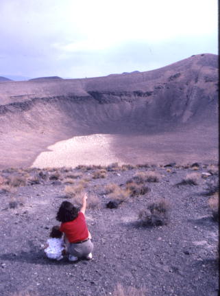
Despite its otherworldly name and appearance, Lunar Crater has decidedly earthly roots. More than three-quarters-of-a-mile wide and 430-feet deep, the giant crater was created by geological rather than extraterrestrial causes.

Scientists who have studied the site believe a tremendous volcanic explosion created 400-acre Lunar Crater, which is located about 77 miles northeast of Tonopah via U.S. 6.

Tens of thousands of years ago, groundwater apparently came into contact with magma or hot rocks near the surface. Steam pressure built underground until an enormous eruption left the giant bowl-shaped hole, which geologists call a “maar.”

The crater sits in a virtual nest of more than a dozen extinct volcanic cones and rock-hard lava flows that is known as the Lunar Crater Volcanic Field.

Early Nye County miners and ranchers considered Lunar Crater an interesting novelty. In 1939, Nevada State Park officials erected a sign on the highway guiding visitors to the site. Later, it became an official U.S. Forest Service attraction.

Part of the fascination of Lunar Crater is the fact that it is part of a much greater volcanic field. From its rim, it is possible to look around and see more than a dozen extinct volcanoes (many are not much more than dark mounds of rock).

Additionally, Lunar Crater has a way of surprising. A visitor will cruise along the seven-mile dirt road leading from the highway to the site, craning his or her neck to see something that looks crater-ish and then, at the top of a small rise in the road, it’s suddenly there.

The crater is big. From its upper edge, visitors look down into a huge, bowl-shaped valley that is difficult to visually measure because it is so large.

Sitting on a wooden bench that overlooks Lunar Crater it is hard not to contemplate the tremendous power of Mother Nature—Lunar Crater was essentially formed by a giant burp in the earth’s crust.

The crater is so massive that it seems to generate its own weather, including fierce winds that scream up its steep walls and blast anyone admiring the view.

Lunar Crater does have a slight connection with outer space. In the 1960s, Apollo astronauts trained in the 140,000-acre volcanic field, which does look like a moonscape, in preparation for a lunar landing. More recently, scientists have tested remote sensing and other technologies for use on future Mars explorations.

In addition to Lunar Crater, a secondary dirt road leads to nearby Easy Chair Crater, a collapsed cinder cone that gained its unusual name because, from a distance, it looks like a giant, overstuffed chair.

Across the highway from the road leading to the two craters is the Black Rock Lava Flow, a more recent formation that covers about 1,900 acres. Visitors studying the dark basalt flow will see specks of green, red, and black glass, which formed because the lava cooled so quickly.

The dirt road leading to Lunar Crater is extremely wash-boarded and a high-clearance, four-wheel drive vehicle is recommended.

Lunar Crater is located about 270 miles southeast of Carson City via U.S. 50, U.S. 95 (to Tonopah) and U.S. 6.

For more information about Lunar Crater, contact the Bureau of Land Management, Tonopah Field Station, 1553 South Main St., P.O. Box 911, Tonopah, NV 89049, 775-482-7800, www.nv.blm.gov.

Friday, November 10, 2006

Beautiful Views at Washoe Lake


Washoe Lake State Park

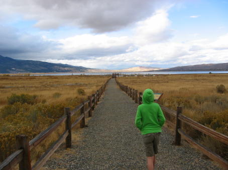
With unobstructed views of Slide Mountain and the surrounding Washoe Valley, Washoe Lake State Park is one of the best places to experience Northern Nevada’s basin and range environment.

On warm days, the lake, which is about four miles long and two miles wide, becomes a haven for water sports enthusiasts. Windsurfing is extremely popular at Washoe Lake as well as Little Washoe Lake, a smaller, sister body of water to the north that is part of the park.

Windsurfers find that due the strong winds that whip down from the mountains to the west provide excellent conditions for riding the lake’s waves.

High above Washoe Lake is Slide Mountain. The native Paiutes called it a name that roughly translates as “mountain that falls down on itself.” About once every century—the last time was in 1983—Slide Mountain releases a wave of mud and rocks.

In fact, in the mid-19th century, humorist Mark Twain wrote about a fictitious legal battle between two ranchers—one wanted his house returned to him after a slide had deposited it on top of his neighbor’s dwelling.

From the park, the 9,600-foot mountain is a beautiful sight with its pine-covered slopes and distinctive half-face topped with snow.

Human settlement at the lake can be traced to migrant bands of native Washo Indians, who often spent winters in the lowlands of the valley and summers at Lake Tahoe. Many used the willows and cattails from Washoe Lake marshes to make baskets and other items.

In 1859—the same year that silver was discovered in nearby Virginia City—Mormon settlers established a community at Franktown on the west side of the valley. Within a short time, two mills opened in the valley to process the ore and the towns of Washoe City, Ophir, and Lakeview had come into existence to supply the mines.

In the 1870s, the Virginia & Truckee Railroad, which extended from Reno to Virginia City, was built through the area and provided a means for transporting goods to and from Washoe Valley.

Washoe State Park was created in 1977 to preserve the valley’s unique natural assets and provide a place for water sport enthusiasts. The park encompasses 8,053 acres and sits at an elevation of about 5,000 feet.

At the Main Area Campground in the center of the park (accessed from Lake Boulevard), Washoe Lake State Park has 49 campsites available on a first-come, first-serve basis. There is also an RV dump station, boat ramps, flush toilets, showers, drinking water, hiking trails, and picnic tables.

The park can accommodate tents or self-contained RVs (up to 45 feet in length) and has 10 RV pull-throughs. There are, however, no hookups for the RVs.

A one-third mile trail from the Main Area Campground winds through sand dunes and leads to the lake. Smaller, undeveloped trails lead around the lake.

A recent addition to the park is a wooden viewing platform and interpretive displays adjacent to the wetlands at the south edge of the park.

The viewing area offers a wonderful overview of the lake and magnificent views of Slide Mountain and the other mountains encircling the valley. You’ll also find a coin-operated telescope on the platform, which allows you to scan the marsh looking for wildlife.

The displays point out that the marsh at the south end of the lake is popular with a variety of waterfowl, which you can occasionally spot, including cranes and herons.

Washoe Lake State Park is located 10 miles north of Carson City and 15 miles south of Reno via U.S. 395 north and the East Lake Boulevard exit. It is open all year.

Admission to the park is $3 per person; $11 per night for a campsite.
For park information, call 775-687-4319.

Monday, November 06, 2006

Recalling Nevada's Oddest Pipedreams


Goldfield School

It should probably come as no surprise that in a state built by dreamers—in the early days it was miners and more recently, gamblers—some amazing and outrageous proposals have cropped up over the years.

Some, like Adolph Sutro’s dream of building a four-mile-long tunnel underneath Virginia City to drain hot water from its mines or the 1,149-foot Stratosphere Tower in Las Vegas, were actually constructed. Others, however, proved to be more illusory.

For instance, in the early 20th century, the president of the Lake Tahoe and San Francisco Water Works, A.W. Von Schmidt, suggested constructing a massive pipeline from Lake Tahoe could solve San Francisco’s water woes.

Author David W. Toll writes that Von Schmidt’s $17 million plan would deliver thirty million gallons of Tahoe water per day—and he was even willing to deliver as much as a hundred million gallons per day for the right price.

Apparently, the idea had sufficient legs that the San Francisco Board of Supervisors visited the proposed site of his diversion dam on the Truckee River before letting the proposal fade away.

Tahoe’s water, however, cast a strong spell on San Francisco. Toll notes that three years later a San Francisco attorney named Waymire wanted to drill a tunnel through the side of the Tahoe Basin to drain lake water into the Rubicon branch of the American River, which would be routed to the city.

Of course, the idea of draining Lake Tahoe wasn’t purely a Golden State notion. Sometime in the 19th century, there was a proposal to drill a tunnel from Washoe Valley to a point deep below Lake Tahoe so that water could be diverted to Virginia City and other parts of Northern Nevada.

More recently, many of the more noteworthy flights of developmental fancy have involved various hotel-casino related projects that never reached fruition. In the 1960s, Reno resort owner William Harrah purchased a huge tract of land along Interstate 80 near Verdi and began planning to build a giant, indoor theme park.

The project, known as Harrah’s World, called for a massive dome over the park, so that it could be used year-round, and included acres of museum space for his famous car collection as well as amusement park rides, a train and, of course, a hotel-casino.

Harrah died before he could begin construction and the project was abandoned.
In rural Nevada, perhaps the most ambitious resort development was an effort in the 1980s to restore the historic Goldfield Hotel, which opened in 1908. A San Francisco developer spent millions to renovate the structure that had been abandoned since about the 1960s.

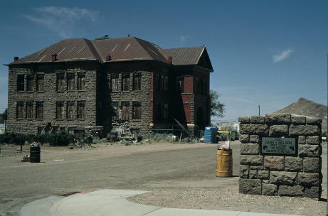
He also bought up other historic structures in the community, including the Goldfield High School, and announced plans to transform Goldfield into a kind of 19th century mining town version of Williamsburg, with residents dressed in period costumes.

Sadly, his vision proved bigger than his checkbook and, after sinking a considerable amount of money into the project, he ran short of funds. A couple of years later, the hotel was auctioned by the county for unpaid back taxes.

A rural project that never made it past the blueprint stage was a plan in the early 1990s to construct a Science and Technology Museum in Nye County, near Amargosa.

The idea was to take money that the federal government was going to give to the county in exchange for building a national nuclear waste dump and sink it into a large science museum in the desert. A scale model was produced of the project—I know because I saw it—but the funding never materialized and it was never built.

One of the most controversial projects that never happened was the MX Missile system, an ambitious proposal to construct hundreds of miles of subterranean railroad tracks throughout Central Nevada.

Missile launchers on trains would scurry around on the tracks, never staying in one place too long. In the event of a confrontation between the U.S. and Russia, the missiles could be routed to convenient launching sites and fired.

Fortunately, the Cold War began to thaw before it could be built.

Not surprisingly, Las Vegas has had its share of unorthodox proposals. In the early 1990s, Las Vegas officials were searching for ways to boost the fortunes of the city’s aging downtown core.

One of the more creative solutions came from several downtown casino owners who proposed replacing downtown streets with a series of water canals. Boat rides on “Las Venice,” as some called it, would attract tourists and the canals would be lined with trendy shops and restaurants, in addition to the hotel-casinos.

Water for the canals would come from a layer of unused but polluted water that sits underneath the downtown. The concept called for the water to be cleaned up and recycled for use in the canals.

Writing about the plan years later, Las Vegas journalist Geoff Schumacher noted that the idea “gained some momentum until somebody mentioned that tourists might end up watching homeless men bathing in the trickling Venetian waters.”

Schumacher said another plan under consideration at the time was to construct downtown a full-size replica of the Starship Enterprise from the “Star Trek” TV show. The vessel would be 23 stories high and 600 feet long and would include a thrill ride, restaurants and convention facilities.

Over the years, there have been a number of unusual Las Vegas resort concepts that never were constructed. In the 1990s, casino owner Bob Stupak, who built the Stratosphere, announced he was going to erect a hotel that would be a full-size replica of the Titanic that would sink nightly.

More recently, a Las Vegas Strip mall announced it was going to build a 22,000 square foot fake Grand Canyon. This faux natural wonder would have theatrical special effects like flash floods and thunderstorms, and visitors could take a ride on a simulated helicopter over the canyon.

But, like so many of these other grand schemes, it dispersed into the fog of ideas whose time never quite came.

Friday, November 03, 2006

Getting Away from it all in Belmont


Belmont Inn

If there was ever a place where you could believe that you’ve managed to escape from the hassles and pressures of daily life, it’s the rustic Belmont Inn in the historic Central Nevada mining town of Belmont.

Located about 40 miles northeast of Tonopah, Belmont can trace its beginnings to the discovery of silver in 1865. Within a few years, the town has grown to include about 5,000 residents.

In 1867, Belmont was designated the seat of Nye County and a few years later, in 1876, it constructed an impressive a two-story Italianate-style brick courthouse.

During Belmont’s heyday—which lasted from the late 1860s to about the late 1870s—the town was a beehive of building activity, boasting a bank, a couple of churches, a school, a post office, several stores and saloons.

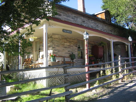
It was during this period, in about 1866, that the distinctive two-story structure that houses the Belmont Inn was constructed. Built of wood and local limestone, the Inn originally served as the offices of the Combination Silver Mining Company.

The building was converted to a private residence several decades ago and, more recently, transformed into a bed and breakfast with five guestrooms.

The Inn, operated by Henry and Bertie Berg, is a wonder. It’s been lovingly restored so that guests can enjoy quiet, comfortable quarters in a quaint, historic setting.

Behind the main house, the Berg’s have rebuilt an old stone miner’s cabin and offer it as a kind of “honeymoon” cottage that offers plenty of privacy, although without running water or electricity. However, candles have been strategically placed around the room to provide illumination.

Large groups more interested in “roughing it,” can rent an old bunkhouse behind the main house, which has accommodations for up to ten additional guests.

The guestrooms, however, are only part of the story. The Belmont Inn also has its own, old-time saloon—Henry Berg is a great bartender who knows not only how to pour a good stiff one but lots of great anecdotes and stories about the area.

Not to be overlooked are the breakfasts, cooked by Bertie Berg. She prepares hearty, tasty fare that can include pancakes, sausage, biscuits, fruit and other delicacies.

The charm of spending time in Belmont is having a chance to explore the old mining town. The town’s silver mines began to slump after 1876. By 1890, only about 150 people remained in the town.

Jim Butler’s discovery of huge silver deposits in Tonopah in 1900 accelerated Belmont’s demise. In 1905, the county seat was moved to Tonopah and Belmont’s fine courthouse, which is now a historic state park, was closed.

Despite the years of neglect, it’s still possible to find glimpses of the settlement that once rivaled Virginia City. With more than a dozen buildings sprouting out of the sagebrush and a number of substantial ruins, Belmont looks and feels like a genuine ghost town.

For instance, at the south end of town is the Belmont Cemetery, which contains a handful of hand-carved wooden markers and is the final resting place of the infamous Nevada gunslinger Jack Longstreet and his wife.

The Belmont-Monitor Mill, located north of the cemetery, was one of several mills erected in the area in the 1870s. The site’s extensive brick ruins include a 15-foot brick smokestack.

East of the Belmont-Monitor Mill site is the main part of the town. Newer homes have been built around the ruins during the past couple of years. The main street, which leads to the Belmont Inn, is lined with a picturesque row of dilapidated brick and wooden storefronts.

Behind this row of structures is a dirt road leading to the Belmont Courthouse, which has been stabilized by the state parks. Guided tours of the courthouse are offered during the summer.

Southeast of the Belmont Inn are other ruins, including the remains of a massive brick kiln with a 20-foot smokestack. About a quarter mile west of the brick oven, is the site of the former Highbridge Mill. The two-story building retains its large, nine-window brick façade.

While exploring Belmont is encouraged, visitors are cautioned not to touch or take anything so that the town can be preserved for future generations.

For more information about Belmont and the Belmont Inn, call 775-482-2000 or go to www.belmontinn.com.

Tuesday, October 17, 2006

Ash Meadows is an Unexpected Treat


Some folks look at Nevada’s wide, open expanses and see nothing.

Those in the know look at the same landscape and see it for what it is—a biological wonderland filled with unique plants, fish, and animal life.

One of the best places in Nevada to discover the desert’s hidden life forms is Ash Meadows Wildlife Refuge, located in southwestern Nevada, about 90 miles north of Las Vegas.

The first thing you notice about Ash Meadows is that it doesn’t look much different from the rest of Southern Nevada. You see acres of gently rolling hills, occasionally populated by sagebrush, juniper trees, and mesquite bushes. But upon closer look you’ll find there’s much more to Ash Meadows.

In fact, this little pocket of rural Nevada boasts the greatest concentration of endemic species in the United States. Some 24 different species of plants, fish, and animal life are only found at Ash Meadows.

The Ash Meadows refuge, which encompasses about 22,000 acres, was originally part of a large Amargosa Valley alfalfa ranch, which was later used for cattle ranching.

In 1984, the nature conservancy purchased a portion of the ranch to prevent it from being further developed. A few years later, the area was designated a national wildlife refuge and came under the management of the U.S. Fish and Wildlife Service. In 1994, a small part of the wildlife refuge, the site of a natural area known as Devil’s Hole, was made part of the Death Valley National Park.

One of the main reasons that Ash Meadows was made into a nature preserve was because of the presence of a tiny creature known as the Devil’s Hole pupfish. This inch-long, nearly transparent fish can only be found at Devil’s Hole, which is a deep, narrow crevice in the ground that is filled with natural spring water.

This small body of water is the only place in the world that the devil’s hole pupfish proliferates. About 90 percent of this endangered species lives within 20 feet of the water’s surface and spawn on a submerged rock ledge.

Ground water usage in the surrounding Amargosa Valley is strictly regulated to ensure that the water level in Devil’s Hole doesn’t drop below the level necessary to support the pupfish population. Scientists believe the springs throughout the valley are linked so that any change in the water table, such as that caused by excessive groundwater pumping, can have an adverse effect on the pupfish.

The reason so many springs are clustered at Ash Meadows is that it is a major discharge point for a large underground aquifer, believed to stretch nearly 100 miles to the northeast. Apparently, a prominent geological fault at Ash Meadows blocks the underground flow of the aquifer and forces the water to the surface. Because this water is thought to have entered the ground thousands of years ago, it is known as “fossil water.”

The Devil’s Hole pupfish isn’t the only unique species of fish found at Ash Meadows. On the refuge you can find about a half-dozen spring-fed pools, and nearly each has its own one-of-a-kind species.

For example, the Ash Meadows Amargosa Pupfish thrives in a warm water pond called crystal springs while the Warm Springs Pupfish is only found in a pond known, not surprisingly, as Warm Springs. Additionally, at Jackrabbit Spring, you’ll spot the endangered Ash Meadows speckled dace, another type of tiny fish.

Each pool is believed to have once been part of a larger body of water that eventually receded into smaller, separate ponds. Over time, subgroups of pupfish evolved, each genetically different from the others.

Walking through the refuge is a peaceful experience. A few hundred yards from the dirt road leading into the refuge, it’s not uncommon to spot small herds of wild horses and wild burros foraging in the area.

A short walk from the main parking area leads you to crystal spring interpretive boardwalk. This wooden walkway allows you to safely view some of the unique plants found at Ash Meadows, such as the threatened Ash Meadows Ivesia and the Ash Meadows Gumplant.

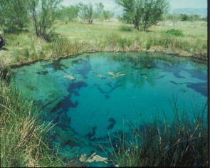
The boardwalk also provides a platform for viewing crystal spring, which is so-named because of its sparkling, inviting, clear blue waters. Standing on the grassy edge of the warm, spring-fed pond, which is about the size of a typical backyard swimming pool, you can see small bubbles rising from somewhere below.

It you look closely into the water, which is about 85 degrees, you can see the tiny pupfish swimming around a submerged rock ledge, looking like tiny, silvery, nearly see-through sardines. It is kind of humbling to look at these little fish darting through the water and realize that they represent all the members of their particular species in the entire world.

Ash Meadows is home to seven species of plants that are either endangered or threatened, including the Amargosa niterwort, the Ash Meadows milk-vetch, and the Ash Meadows sunray. The Ash Meadows naucorid, a water-based beetle, is also on the list of threatened insects.

239 different species of birds have been sited at the refuge, including endangered falcons and bald eagles, which makes it popular for bird watching the best time of year to spot birds is during the spring and fall migrations.

Among the remnants of the old cattle ranch that was once on the site of the refuge are two large, manmade lakes, fed by overflow from some of the springs. At one of them, Crystal Lake, swimming is allowed.

The long-term goal of the wildlife service is to remove any unnecessary roads and buildings as well as the more than 100 non-native plants and animals that were introduced into the region by past development.

For more information about the Ash Meadows National Wildlife Refuge, call 775-372-5435.

The Story of the Felling of Prometheus

  In the summer of 1964 a geography graduate student named Donald L. Currey, with permission from the U.S. Forest Service, cut down a bristl...