Saturday, July 30, 2022

Daveytown Turned Out to be No Gravy Train


   The story of the old mining camp of Daveytown, located directly west of U.S. 95, about 30 miles northwest of Winnemucca, is no different from that of dozens of mining towns strewn across the state of Nevada.

   Gold was discovered in the area in 1910 and within a few months a small camp had grown. Originally known as Awakening, apparently a pun because the site was on the east slope of Slumbering Hills, it soon had a saloon, a general store, and a handful of houses and other businesses.

   By 1912, sufficient gold ore was being produced that it was being shipped to processing facilities in other communities and Awakening’s future seemed secure.

   Over the next half-decade, three mills opened in the area to handle the ore and the camp’s name was changed to Daveytown, which apparently derived from the nearby Davey Mine.

   But, like so many other Nevada mining camps, the boom was short-lived. By the mid-1920s, the mines had closed and most residents had picked up and moved on.

   New discoveries in 1935, however, reignited interest in the region, particularly following the opening of the Jumbo Mine (so named because it seemed to contain such a large quantity of ore).

   This second wave spurred new development and investment in the local mines, which were even visited in 1936 by former President Herbert Hoover, a mining engineer, who had a keen interest in Nevada mines.

   In his invaluable reference book, “Nevada Ghost Towns and Mining Camps,” author Stanley Paher noted that Daveytown and the Jumbo Mine received a substantial amount of attention in the media in the late 1930s, including articles in West Coast newspapers and on the “March of Time” national radio program.

   In 1937, oil man H.L. Hunt of Texas and several partners secured a long-term lease on the Jumbo Mine, but lost it following a legal dispute. Between the mid-1930s and 1941, the Jumbo remained a consistent gold producer and lived up to its name.

   Following World War II, when most Nevada mines were closed, the Daveytown area mines reopened for a few years before finally shutting down in the early 1950s.

   Since then, the community has been gradually melting back into the dirt and sagebrush. Today, visitors who find the site, which is reached after following an ungraded dirt road for about 12 miles, will see one fairly intact wooden house with a rusted metal roof as well as the wooden foundations of an old mill.

   The area is also littered with mounds of rusted metal panels and weathered wood beams and other decaying remnants of the town. Across the dirt road from the main section of ruins, you can find the rusted skeleton of an abandoned 1930s-era automobile.

   The site is particularly popular among ghost town photographers, who seem enchanted with the old automobile as well as off-road explorers and ghost town enthusiasts.

   The town also has a geocache, which was featured a few years ago on the Reno PBS television program, “Wild Nevada.” You can view the episode here: https://watch.pbsreno.org/video/episode-205-winnemucca-to-paradise-valley-zeiv2n/).

   For more information about Daveytown (or Jumbo), contact the Humboldt County Museum in Winnemucca, 175 Museum Lane, Winnemucca or go to http://humboldtmuseum.org.


Saturday, July 23, 2022

Nineteenth Century Hoaxes and Hair-Raising Adventures in the Pahranagat Valley


  During the past year or so, I have been working on a book about Nevada’s frontier journalists (more about that in a future column). As a result of my research, I’ve gained a greater appreciation for these talented and creative ink-stained pioneers, particularly Virginia City journalist William Wright, who wrote under the pen name, Dan De Quille.

  One of the most famous stories every crafted in 1867 by De Quille involves the remote Pahranagat Valley in eastern Nevada. The valley is located about 75 miles northeast of Las Vegas on U.S. 93.

  At a time when newspapers liberally borrowed stories from each other, De Quille’s piece, which originally was printed in Virginia City’s famous Territorial Enterprise, appeared in papers all over the world and as far away as New Zealand.

  De Quille wrote of meeting a man from the Pahranagat Valley who showed him a half dozen pebbles that were almost perfectly round. The man said that the rocks were “rolling stones,” which, when spread out, would gravitate together “like a bunch of eggs in a nest.”

  De Quille described how the man would set the stones on a floor or table in a circle and the rocks would begin moving toward each other. He speculated that the stones probably rolled together because they were made of lodestone or magnetic iron ore.

  After the story appeared in the Enterprise as well as other newspapers, it generated a flood of letters from people curious about the marvelous rolling stones. De Quille reported that P.T. Barnum wrote him to offer $10,000 if the rocks could be coaxed into performing under a circus tent.

  In 1879, De Quille finally tired of having to repeat the story and wrote a short article in the Enterprise that revealed he had made up the whole story. Many, however, refused to believe his retraction and thought he was lying in order to keep the rocks for himself.

  Interestingly, the Pahranagat area also figured prominently in one of the most hair-raising adventures ever experienced by a Nevada governor.

  In March 1866, Nevada’s first governor, Henry Blasdel, decided to travel to eastern Nevada to organize settlers in the area to support the creation of a new county.

  The Governor had received promising reports about the mining potential in the Pahranagat Valley and was interested in seeing the region, which was part of the Utah Territory but had been proposed for inclusion into Nevada.

  Additionally, Blasdel sought to establish a direct route to the area from western Nevada.

  The journey proved arduous; with the scarcity of water being the biggest challenge. Blasdel’s party decided to head south from Carson City to Silver Peak (near Tonopah) and continued south into Death Valley.

  As the group entered Death Valley, it lost contact with Carson City. No one would hear from Blasdel or his party for more than a month. The Sacramento Bee reported that the expedition had failed and its members had most likely perished.

  In late May, news reached Carson City that the group had straggled into Pahranagat. A newspaper reporter traveling with the Governor later wrote that the only things that members of the expedition had to eat had been a few doves and lizards that wandered into camp. He added, however, that cooked lizards were “equal to any frogs that were ever roasted.”

  After returning to Carson City by way of an already-established but longer northern route, Blasdel acknowledged that his venture had not been successful because there weren’t enough people in Pahranagat to form a county.

  He also said that he would not recommend his short cut to Pahranagat because the trip was far too difficult.

  In 1866, Pahranagat became part of the newly created Lincoln County, with the tiny settlement of Crystal Springs, which is 15 miles north of the Pahranagat Valley, named the county seat.

  A year later, the seat was moved to Hiko, located five miles north of Crystal Springs—and not much bigger—and, then, in 1871, to the much larger community of Pioche.

  These days, the Pahranagat Valley, which is a long, narrow crevice intersected by the Upper and Lower Pahranagat Lakes, is a quiet, sparsely populated place that is home to more birds than people.

  The two scenic lakes that stretch through its center are part of the Pahranagat National Wildlife Refuge, making the region a true, natural oasis—and, of course, the backdrop for some pretty good stories.


Friday, July 15, 2022

Nature on Display at Reno's Wilbur D. May Arboretum and Botanical Garden

   It’s not everyday that you can see a Japanese yew or a patch of Mexican hats in Reno. But both are among the many exotic plant species that can be found in the Wilbur D. May Arboretum and Botanical Garden in Rancho San Rafael Park.

   The May Arboretum is a virtual oasis of trees, flowers, shrubs and all things botanical. Hundreds of plants, including native species and more exotic varieties, can be found spread over the arboretum’s 12 acres.

   The arboretum was created in 1982 with funding from the Wilbur May Foundation. Wilbur May, whose family owned the May Company department stores (they merged with Macy’s in 2005), resided in the south Truckee Meadows for many years and was known as a generous philanthropist during his life.

   Perhaps the best aspect of the arboretum is its overall peacefulness. Just minutes from the hustle and bustle of downtown Reno, you can park and walk into lush, green gardens intersected by a gurgling stream. The trees are home to several dozen different varieties of birds including golden eagles, falcons, owls, ducks and geese.

   The arboretum grounds are divided into more than a dozen different gardens and groves, each with a different theme or atmosphere.

   For instance, at the south entrance near the park offices, you wander immediately into the Kleiner Oak Grove, a forest of different varieties of oaks that exhibit brilliant red colors in the fall.

   Ahead is the Columbus Garden with its lovely ivy-covered gazebo, while adjacent are the Burke Garden, which is styled after an English country garden with flowering perennials (quite beautiful in the spring).

   Honey’s Garden, located nearby, features small, manmade waterfalls cascading over boulders and into small ponds. Here, you’ll find a plethora of white and yellow flowers.

   Continuing into the sloping terrain, you can either head west into a series of small gardens including the Songbird Garden, which contains more than 200 varieties of aromatic flowers and trees attractive to birds.

   The garden was established in 1985 to foster bird watching at the arboretum. The park’s custodians estimate that more than 50 types of birds can be found throughout the arboretum.

   Nearby Kirsten’s Garden, which has a secluded gazebo and is filled with wisteria, iris, magnolia and other plants.

   A picturesque redwood bridge crosses Evans Creek, which winds through the arboretum, and leads to the May Grove and the Kleiner Hardwood Grove, both of which are located on slopes overlooking the creek.

   The former supports a stand of evergreens while the latter has mid-western and eastern native deciduous hardwood trees.

   At several places along the creek, you’ll find quiet, shaded, grassy spots that are ideal for sitting and reading a book, picnicking, or just contemplating nature’s wonders.

   The main trail continues northwest to several other groves of trees and leads up to the Irwin Overlook, located on the crest of the hill above the creek and arboretum. Here, interpretive signs describe the geology, plants and animal life of the region. This spot also offers a nice view of the entire park.

   The Lear Garden at the end of the trail contains a large, round gazebo, a popular site for weddings.

   Below the Overlook is the Herman Pond Nature Trail, which leads from the arboretum to Herman Pond, a manmade body of water that, when I visited, was quite popular with flocks of duck and geese.

   The Wilbur D. May Arboretum and Botanical Garden is open daily sunrise to sunset. There is no admission charge. The arboretum is located at Ranch San Rafael Park, 1502 Washington Street, in Reno.

   For more information go to www.washoecounty.gov/parks/maycenterhome/arboretum/. Download the arboretum’s brochure for a guide to the various gardens.


Monday, July 04, 2022

Our Little Piece of Paradise....Somewhere Out There in Pershing County


  Annually, my wife and I receive a tax bill from the Pershing County Treasurer’s Office for about $60. The bill isn’t for some grand vacation home that we own in Unionville or the banks of Rye Patch, but rather for 10 acres of vacant land that my wife received from her late father.

  Apparently, her dad—who really coveted his privacy and independence—bought the land decades ago thinking he might one day plop a trailer on it, maybe sink a well, and set up a generator.

  Alas, none of that ever happened and so we now own the parcel, which is located somewhere in the vastness of sagebrush and dirt known as the Dun Glen Flat/Buena Vista Valley, about halfway between Lovelock and Winnemucca.

  When my wife’s father deeded the land to us, he provided a promotional pamphlet and survey map. The pamphlet generously described the parcel as a “ranchero” and painted a fine portrait of the area as part of a series of small ranches where owners could indulge in their western dreams.

  It promoted the joys of country living—of building your own little spread on the site and maybe raising horses or growing something.

  Of course, that was all certainly possible—except for the fact there are no roads to the property along with no water, sewer or power infrastructure.

  The original agreement for the sale of the land, located about a dozen miles south of Mill City, off State Route 400 (the road leading to the ghost town of Unionville), officially describes it as: “The E 1/2 of S1/2 of SW1/4 of NW 1/4 of Sec.27, R35E, T32N, MDBM, of Pershing County, Nevada, 10 acres. (13-E).”

  In recent years, we receive occasional offers to purchase our land, mostly from out-of-state water companies trying to consolidate all the water rights in the valley to sell to Reno or some other larger city. The offers are always small and not very tempting, so we pass.

  So, why pay the taxes on this parcel year-after-year? I think it’s because the land has sentimental value as it was once owned by my wife’s dad, and because it’s a great conversation piece.

  For years, we’ve joked with friends about retiring to our “estate” in the country and I’ve told folks it’s where I want my ashes spread when my time comes up (assuming anyone could find the exact 10 acres out in the vastness of that valley!).

  In fact, several years ago we tried to find our parcel. We headed east of Reno on the interstate, traveling about 93 miles to Lovelock. We continued east on I-80 for another 42 miles to the Mill City exit. There, we headed south on SR 400.

  The map in our files indicated that the parcel was about 12 miles south of Mill City, and apparently some unknown distance from the road.

  Despite having the helpful and detailed deed description (you know—“The E 1/2 of S 1/2 etc.”), we quickly realized that other than a couple of fairly large ranches there wasn’t much out in the way of landmarks in Dun Glen Flat or adjacent Buena Vista Valley.

  At one point during that visit, a local rancher came along in his truck as we stood by the side of the road scanning the vast open space for some clue as to the site of our land (I guess we were expecting a big sign or a neon arrow or something) and asked if our vehicle had broken down. I mean why else would we be standing there in the middle of Nevada?

  We told him about our quest to locate our land and described what we were looking for. He scratched his head thinking about it for a moment and then remembered that the only ten-acre lots were a few miles north, near what one of our road atlases called the Star Creek Ranch.

  He said nearly all the rest of the lots in the valley that weren’t part of larger ranches were a minimum of 20 acres.

  We drove back to the spot he had indicated and looked out over the desert. Just beyond a barbed wire fence we could see—more nothingness.

  All of the land around us was cracked and dry, with the general flatness broken by occasional gray-green mounds of scruffy sagebrush. Here and there, you could see rocks peeking through the thin, yellow-brown grass that barely covered the ground.

  In the distance, we could see a large patch of green—apparently the Star Creek Ranch grew alfalfa.

  Unable to determine exactly which vacant acreage was our vacant ten acres, we wandered into the desert for a little while and imagined we were looking at our land.

  I tried to envision where we would put the swimming pool, the tennis court and the satellite dish. Heck, a fishing pond might be nice.

  In the end, we decided it was enough knowing that somewhere out there was ten acres that was all our own.

  Even if we had no idea where exactly it was.


Monday, June 27, 2022

Great Basin National Park's Often-Overlooked Osceola Ditch Trail


   Few visitors to Nevada’s Great Basin National Park notice the sign indicating the trailhead for the Osceola Ditch Interpretive Trail—which is a shame because there’s a fascinating story behind the ditch as well as the town to which it once provided water.

   The interpretive trail can be found about 4.6 miles from the start of the Wheeler Peak Scenic Road. A sign notes the trail location, with parking on the right side of the highway.

   While today little remains of the actual ditch, in the late 19th century it was an engineering achievement. Gold was discovered in about 1872 in what would become known as the Osceola Mining District (which is located three miles west of Great Basin National Park; accessible by dirt road from U.S. 50 at the Sacramento Pass Recreation/Rest Area).

   Prospectors James Matteson and Frank Heck made the initial gold ore discovery and within a short time other miners poured into the area seeking to make their fortunes. Within two years, Osceola had 250 residents and by 1882 a town of about 1,500 people had sprouted on the northwest side of Mount Wheeler.

   Since there weren’t any major sources of water near the mining district, which was located in a deep ravine, the miners decided to construct a 16-mile ditch to drain water off the western slope of the South Snake Range.

   This ditch, completed in 1885, cost more than $80,000 to build and employed more than 175 workers. The water from the ditch (called the West Ditch) allowed a limited hydraulic mining (essentially blasting the ravine with pressurized water to free up any gold) and inspired the miners to build a second ditch to bring even more water to the area.

   This second canal, which was 18 miles long, was designed to carry water from streams located to the southeast, including Lehman Creek. This water system, built between 1889-1890, cost more than $108,000 and involved some 300 workers, many of whom were Chinese or local Native Americans.

   The second (or East) ditch (part of which is today’s Osceola Ditch Trail) required constructing miles of wooden flumes as well as blasting a 600-foot tunnel through rock outcroppings.

   Adding the second canal ultimately didn’t substantially improve the haul from Osceola’s mines. Additionally, several dry winters in a row meant very little water was available to divert to either of the ditches.

   By 1900, the whole ditch project was abandoned. Today, the Ditch Trail retraces the path of the old flume and passes a tunnel that had to be blasted in the rock at one spot.

   Despite the ditch’s apparent lack of success, Osceola was a fairly productive (generating about $2 million) and relatively long-lived mining camp. In 1877, one of the world’s largest gold nuggets was discovered at the Osceola site, a chunk of ore weighing 24 pounds.

   Little remains of the former town of Osceola, which once boasted two stores, a hotel, a Chinese restaurant, livery stable, post office and several saloons. Visitors can still find the stone walls of the former general store, a handful of wooden structures and, on the roadside hill west of the town site, a fairly impressive cemetery.

   Much of the site is on private property—mining has been done sporadically over the years—so be courteous and respectful of the property owners.

   For more information, go to the National Park Service web site, www.nps.gov/grba/historyculture/the-osceola-ditch.htm, or to the Exploring Great Basin website, https://www.exploringgreatbasin.net/?q=content/3-osceola-ditch-interpretive-trail.


Wednesday, June 15, 2022

Santa Rosa's Burbank Gardens Offer Tranquility and History

  Tucked into a half-acre lot in the heart of the Northern California city of Santa Rosa is a picturesque city park that celebrates the life and works of renowned botanist and horticulturalist Luther Burbank, who is credited with introducing more than 250 new varieties of fruit.

  Known officially as the Luther Burbank Home and Gardens, the park at the corner of Santa Rosa and Sonoma Avenues, commemorates the life of a man largely forgotten today, but, during his lifetime, was often referred to as “the Plant Wizard” because of his efforts to create new and better varieties of fruits.

  Burbank was born in Lancaster, Massachusetts in 1849 and from an early age showed a fascination with plants. In 1867, following his father’s death, Burbank used his inheritance to purchase a 17-acre farm, where he developed what became known as the Burbank potato, a variety that was more resistant to the blight that had wiped out potato harvests all over the world.

  He sold the rights to the Burbank potato and used the proceeds to relocate to Santa Rosa, California, where he purchased a four-acre lot and built a greenhouse, nursery and experimental crop fields, where he could work on developing new varieties of plants using crossbreeding.

  To market his discoveries, Burbank published regular plant catalogs, including his famous 1893 “New Creations in Fruits and Flowers,” and marketed his new species.

  That same year, Clarence McDowell Starks, co-owner of one of the nation’s largest orchard companies, agreed to pay Burbank $9,000 in return for the rights to three of his new fruit varieties. Burbank said the arrangement finally helped make his life’s work profitable.

  As Burbank’s fame grew, so did his access to grant funding, including from the Carnegie Corporation. Over the years, he became friends with many of the era’s most acclaimed inventors and businessmen, including Henry Ford and Thomas Edison.

  Burbank died in 1926 of heart failure. He was buried beneath a large Cedar of Lebanon tree in his gardens.

  Following Burbank’s death, his wife, Elizabeth, lived in the cottage on the garden property (until her death in 1977) and, over time, disposed of his assets and patents. In the 1970s, the property was acquired by the City of Santa Rosa and converted into a public park.

  Visitors to the site today will find a peaceful, picturesque setting with rows, plots and hedges of various fruits, vegetables, and other plants. Among the unique plants found on the site are a “multi-grafted apple tree,” which Burbank used in his grafting experiments. The tree has more than 50 separate cultivars grafted onto it, including fresh-eating and cider apples.

  Additionally, there is a garden devoted to medicinal herbs, which Burbank experimented with and improved upon, a giant cactus plant, various prune and apple trees, flowers, shrubs and a host of other plant species.

  The property also has the cottage that Burbank lived in for many years (and, later, was the home of his wife) as well a brick-and-glass greenhouse, a large barn and other smaller storage buildings.

  A virtual tour of the cottage can be found on the park’s website or on Youtube, https://www.youtube.com/watch?v=Bh3x9sbimHc&feature=emb_logo.

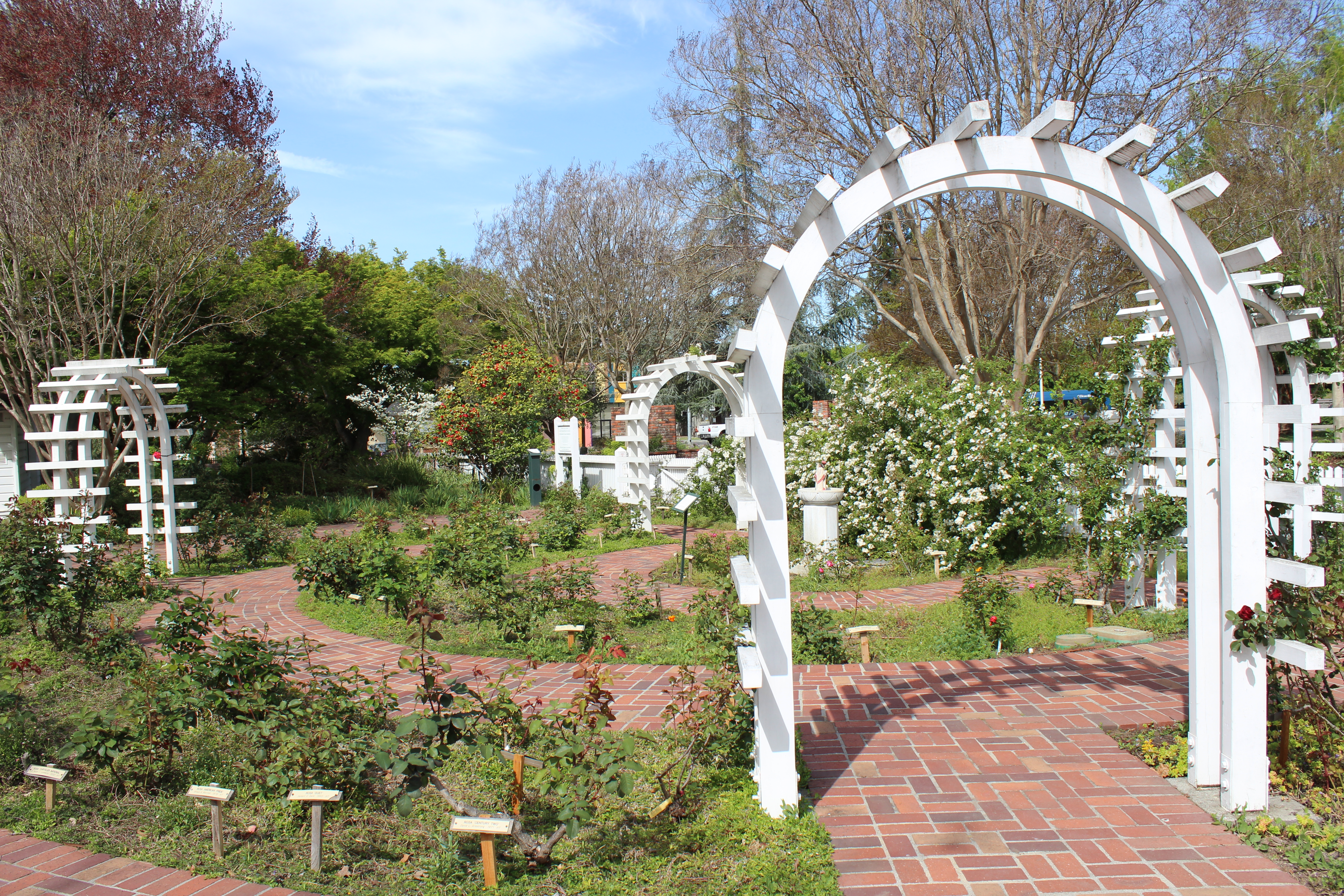
  At the entrance to the park is a brick walkway leading to a scenic fountain and wooden trellis covered with plants, while to the north end, past the barn, is a beautiful rose and flower garden with white, wooden arches.

  Entry into the park, open to the public on Sunday, Monday, and Wednesdays from 8 a.m. to dusk, and Tuesday, Thursday, and Saturdays from 1 p.m. to dusk, is free. Tours, the small museum and gift shop are available Tuesday through Sunday, 1 p.m. to 4 p.m.

  For more information, go to: http://www.lutherburbank.org/.


Friday, June 03, 2022

The Founding of Reno's Rancho San Rafael Park

  Any study of the effort to create Reno’s Rancho San Rafael Park must begin with Clark Santini.

  The brother of former Nevada Congressman Jim Santini and nephew of famed Nevada writer Walter Van Tilburg Clark, Clark Santini had previously worked on the successful effort to create a state park at Tule Springs in Southern Nevada.

  According to Nevada historian Elmer Rusco, who authored a 1998 study on the effort to create the park, “The Benchmarks of . . . Character and Way of Life: The Acquisition of Rancho San Rafael Regional Park,” Santini’s involvement began in 1976 when he and several friends met to discuss somehow converting the ranch, one of the last large parcels of open land in the city, into a public park.

  “Santini brought up the information that the ranch was for sale and broached the idea . . . of attempting to interest all three local government entities—Washoe County, Reno and Sparks—into jointly purchasing it as a regional park,” Rusco wrote.

  He added that after the group, which included Virginia and Bob Kersey, Rabbi Abraham Feinberg and Patricia Blanchard, agreed to push ahead with the idea, Santini, who passed away in 1996, was designated the main spokesman for the effort and was later even called “father of Rancho San Rafael.”

  During the next three years, Santini’s group succeeded in getting legal authorization from the Nevada state legislature for a bond election to pay for acquiring the property. Additionally, with the support of former Sparks Assemblyman Don Mello, park supporters worked with Nevada’s Public Employees Retirement System (PERS) to purchase the ranch as an investment, and then sell it to Washoe County, once the bond passed.

  In the event that the bond failed, PERS would be free to sell the land to private investors, thereby recouping its investment.

  According to Rusco, in January 1979 PERS bought the 408-acre ranch for $7.5 million and agreed to sell it to the county at that cost, plus 15 percent for each year required for the transfer. The county had five years to complete the deal.

  On June 5, 1979, the bond was approved overwhelmingly, gaining nearly 62 percent of the total votes cast on the question.

  Since it was created, Rancho San Rafael Park has been expanded twice. In 1993, a land donation from the late Reno businessman William Thornton and his wife, Dr. Barbara Thornton, a longtime professor at the University of Nevada Reno, enlarged the park by another 120 acres. Five years later, the park gained another 42 acres located in nearby Keystone Canyon as a result of a land exchange.

  Interestingly, there had been several previous attempts to turn the ranch into a park. Rusco noted that in the 1940s, University of Nevada Reno President John O. Moseley attempted to persuade the ranch’s owner, Dr. Raphael Herman, to donate the property to the university.

  Additionally, the University of Nevada, Reno Land Foundation made overtures to purchase the site in the late 1960s but the efforts were unsuccessful.

  Rancho San Rafael traces its beginnings to the early 20th century, when members of the Pincolini family purchased the property in northwest Reno. The Pincolinis apparently used the land for cattle and raised potatoes.

  In 1919, the Pincolini family sold the acreage to Martin Pradere. Shortly after, much of the property was sold to Russell Jensen, who raised sheep on the land. In the mid-1930s, Norman B. and Mariana Herman, along with Dr. Raphael Herman, acquired the land, using it primarily to raise cattle.

  Many of the ranch buildings still standing in the park, including the main ranch house (now used for meetings and conferences), were constructed during the period the Hermans owned the property. The Hermans also enlarged the ranch’s size, purchasing more than 150 adjacent acres during the next few years.

  In the 1960s, Mariana Herman became the sole owner of the property following the death of her husband and his brother, and, later, agreed to sell it to PERS.

  Today, the park totals some 577 acres and is home to the Wilbur D. May Arboretum and Botanical Gardens, the Wilbur D. May Center and museum (a collection of rare and exotic artifacts) and acres of hiking trails, picnic areas, playgrounds, ball fields and lots of open space.

  Additionally, the park hosts several major annual special events including the Great Reno Balloon Race, held each September.

  Rancho San Rafael Park is located at 1595 North Sierra Street in Reno. For more information go to http://www.washoecounty.us/parks/rsrp.htm.

  And if you visit, make sure to take a moment to thank Clark Santini.


The Story of Mary Jo Estep: The Last Survivor of the Battle of Kelley Creek in Northern Nevada

  Posse that hunted Shoshone Mike and his band in 1911 For most of her life, Mary Jo Estep had kept a secret. Born in either Idaho or Nevada...